| Home | Open Account | Help | 369 users online |
|
Member Login
Discussion
Media SharingHostingLibrarySite Info |
Steam & Excursion > Lidar is a game changer for exploring logging railroadsDate: 11/15/19 17:06 Lidar is a game changer for exploring logging railroads Author: PlyWoody Attached is a USGS Lidar image (Hillshade) of the oldest logging railroad in NH overlaid with red line passing under the present Conway Scenic RR at Carroll Brook a mile south of Hazen. The John's River Logging railroad was owned by the A. L. & W. G. Brown & Company built in 1870 and used until 1875. The company replaced this line with the Whitefield & Jefferson RR line in 1875.
On October 6, 1890 the Maine Central RR, as leased operator of the Portland & Odgensburg. built their line from Fabyan to Scotts 17.7 miles and constructed a trestle over the Carroll Brook stream, later filled in over a stone culvert and covering the abandoned grade. That high fill is now Conway Scenic RR. Bottom of image is Quebec Jct wye all grown over with trees. Lidar is a laser image that looks through trees and give you a relief image of the ground. Old railroads were built by manual labor who shoveled side ditches to the center of right of way for level ground for the ties. Those two ditches can be seen in the relief image, and almost all railroad track was built to survey tangent or set curves and much different than wagon travel which turned around every lump of land. Later roads were built with plows that cut ground and leave debris along the sides and Lidar see that as wider and less engineered scars. This is just an example of why exploring of unmapped railroad must use Lidar search before you walk it with a metal detector to find the railroad proof. No metal, likely not a railroad. Also map it out on USGS topo and look at the profile which will be even for the trains but irregular for ground travel. But don't rule out 10% or even 12% for railroad spurs. In a few years, most states will offer access to the Lidar images. Some Wilderness forest seem to be restricted, and some areas are not of high enough quality. You should also search with Google maps and see the ground image with the trees. In answer to some PMs there were large old ties still in the road bed south of the MEC fill, and near the left edge of photo below the red line were very interesting "wash-board" surface as the wood ties rot away and the grass and weeds between the ties make a hump. It is rewarding to locate something that old, but in some places you can only find it whe standing there. Edited 1 time(s). Last edit at 11/16/19 11:09 by PlyWoody. 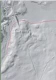 |