| Home | Open Account | Help | 231 users online |
|
Member Login
Discussion
Media SharingHostingLibrarySite Info |
Steam & Excursion > Mining Mallets Under WireDate: 02/22/21 10:02 Mining Mallets Under Wire Author: MacBeau Andreas Feininger of FSA fame found himself in Bingham Canyon, Utah back in November 1942, and recorded what looks to be a former Utah Copper Company compound 0-8-8-0 climbing out of the mine, as well as 103, another 0-8-8-0 crossing the canyon. Last view is of Bingham Canyon, not much of a pit in those days but based on these images alone an incredible show.
Be of good cheer, —Mac www.lowellamrine.com 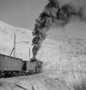 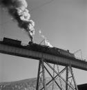 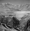 Date: 02/22/21 12:47 Re: Mining Mallets Under Wire Author: MacBeau This color shot by Feininger of Carr Fork Canyon states it was taken from Bridge G. A caption from another image at the base of H suggests at least eight railroad crossings of that canyon.
—Mac Edited 1 time(s). Last edit at 02/22/21 13:30 by MacBeau. 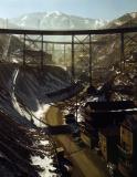 Date: 02/22/21 13:25 Re: Mining Mallets Under Wire Author: Frisco1522 WOW!
Date: 02/22/21 16:41 Re: Mining Mallets Under Wire Author: tomstp They were constantly building more track, right?
Date: 02/22/21 16:54 Re: Mining Mallets Under Wire Author: MacBeau When they weren't building new, they were moving old based on the images in the FSA collection.
tomstp Wrote: ------------------------------------------------------- > They were constantly building more track, right? Date: 02/22/21 18:15 Re: Mining Mallets Under Wire Author: ShoreLineRoute Don Strack may chime in, but I suspect all that Carr Fork Canyon infrastructure was shoveled away as the pit grew over the years.
Oliver Barrett Date: 02/23/21 03:25 Re: Mining Mallets Under Wire Author: refarkas Photo three (the overall view) is breath taking. How small man's achievements are when compared to the mountains!
Bob Date: 02/23/21 04:49 Re: Mining Mallets Under Wire Author: donstrack ShoreLineRoute Wrote:
------------------------------------------------------- > Don Strack may chime in, but I suspect all that > Carr Fork Canyon infrastructure was shoveled away > as the pit grew over the years. Bingham Canyon has fascinated me for well over 40 years. Too many changes to talk about here. The other day I scanned this slide that I took in 1987. It shows the north (right) side of Carr Fork, the same side canyon in the color photo of all the bridges. The north side remained untouched because Utah Copper/Kennecott did not own the ground until the 1985. They held dumping rights on the surface starting in 1924 when the first of the seven bridges in the photo was built. A series of mining companies owned the underground mines on the north side of Carr Fork, and by the late 1940s they were all owned by Anaconda or its direct subsidiaries. In 1974 Anaconda started development of a new underground mine, but lost its way when Atlantic Richfield (ARCO) bought Anaconda in 1977. Development stopped in 1981 and Kennecott bought all of Anaconda's holdings at Bingham in 1985. For anyone interested, I have a bunch of web pages about Bingham Canyon and the mining companies... https://utahrails.net/bingham/bingham-index.php And I wrote a book back in 2011... https://www.arcadiapublishing.com/9780738584898/Bingham-Canyon-Railroads Don Strack 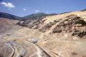 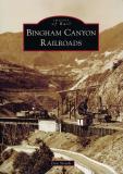 Date: 02/23/21 06:22 Re: Mining Mallets Under Wire Author: howeld If only a time machine existed....definitely on the short list of places to see.
Date: 02/23/21 08:39 Re: Mining Mallets Under Wire Author: MacBeau What an incredible difference. Thanks for the look. Here is a view looking the other way from what looks to be the same bridge.
—Mac Edited 1 time(s). Last edit at 02/23/21 10:53 by MacBeau. 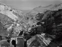 Date: 02/24/21 21:46 Re: Mining Mallets Under Wire Author: coach Utterly, totally fascinating. How in the world did they keep track of such a huge layout of tracks??!! The trains could haul more dirt, so why get rid of them?
I've got to buy that book, and look for this on video. Date: 02/25/21 06:35 Re: Mining Mallets Under Wire Author: donstrack MacBeau Wrote:
------------------------------------------------------- > What an incredible difference. Thanks for the > look. Here is a view looking the other way from > what looks to be the same bridge. > —Mac The view that MacBeau shared is looking down-canyon in a side canyon known as Carr Fork, a name that dates back to the early 1860s when the ore deposits were first discovered. The bridges in the down-canyon photo are the 'D' bridge in the middle distance, and the B&G 'A' bridge in the distance. The photo was likely taken from the 'G' bridge, one of the first bridges built in 1924 to allow railroad access to the dumping grounds on the north side of Carr Fork. The sign on the small wooden bridge in the foreground reads, "National Tunnel & Mines Co.," which is the company which went bankrupt building a 4-1/2 mile railroad tunnel through the mountain to the smelter near Tooele. Anaconda bought full control of National Tunnel & Mines in 1948, giving it full ownership of all the Carr Fork underground mines. Here is a view looking up Carr Fork in about 1910, before the Bingham & Garfield was built in 1911, and after the Bingham Mercantile store was built in 1904. High up on the mountain side on the left (south) side is the Rio Grande Western's line up Carr Fork to serve some of the earliest mines. On the right (north) side is a string of towers of an aerial tram that was used before the railroad was built up Carr Fork. The mountain on the left side is completely gone today, but the road stayed essentially the same, as seen in my photo from 1987. Even today, there remains a road along the edge of the massive open pit that matches the old Carr Fork road. The second photo shows Carr Fork and its bridges at about the same time as the color photo MacBeau shared. This photo is an amazing 8x10 negative that astounds me every time I zoom in and look at the details. I could talk for an hour all about what this photo shows. I have a web page describing the spectacular bridges of Carr Fork... https://utahrails.net/bingham/railroad-bridges.php#carrforkbridges Don Strack Edited 2 time(s). Last edit at 02/25/21 09:00 by donstrack. 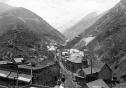 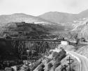 Date: 02/26/21 15:31 Re: Mining Mallets Under Wire Author: LarryDoyle There must be an interesting story about why they used both Mallets and steeple cab electrics. Looks like the electrics used two trolley poles and two closely spaced parallel wires. couldn't the electrics handle the heavy loads, or was it a period of transition? Were the 0-8-8-0's bought new, or what was their heritage? I can't find any mention of them in Lionel Wiener's book Articulated Locomotives, unless they might be 2nd hand which offers these possibilities for which 0-8-8-0's were built
B&O Erie - not likely, as they were camels Central RR of Brazil Delaware & Hudson Norfolk & Western New York Central Birmingham & Garfield (WHO were they?) Pennsylvania - Definatly not PRR LeMassena's book seems to ignore them. -LD -LD Date: 02/26/21 19:17 Re: Mining Mallets Under Wire Author: donstrack That is Bingham & Garfield, the common-carrier subsidiary of Utah Copper Company, who owned and operated the Bingham mine, and the two concentrating mills 16 miles to the north.
I have two web pages for you to read. This one about the railroad... https://utahrails.net/bingham/bingham-garfield.php ...and, this one about all the steam locomotives at Bingham. https://utahrails.net/bingham/kcc-utah-steam.php LeMassena's "Articulated Steam Locomotives of North America" has a section about Kennecott Copper on page 289, with two photos on page 290. There is also a section about Utah Copper and the Bingham & Garfield on page 296, with photos on pages 297 and 298. It was all the same railroad, but like so many railfan authors, LeMassena tries to separate them as if they were different organizations. I see this a lot based solely on the lettering and paint schemes on locomotives, when in fact, the ownership and operation of locomotives can be amazingly complex and complicated, which makes the research so much more interesting. Don Strack Edited 1 time(s). Last edit at 03/16/21 18:30 by donstrack. |