| Home | Open Account | Help | 326 users online |
|
Member Login
Discussion
Media SharingHostingLibrarySite Info |
Nostalgia & History > OS RRDate: 04/21/14 22:38 OS RR Author: fmaffei # 1 & 2 from " The last whistle"
# 2 is looking west from I'm sure is the MS st car trestle over the cut. [which PG&E found when digging to inst. a gas line]look closely and you can see the SP bridge over the cut at the very end of the cut. This was all filled in and is now Alemany & San Jose Ave. # 3 Looking north to Lake Merced and which is now Westlake district of Daly City. Center of photo you can clearly see the remnants of the OSRR from right to left. FM photo 1947 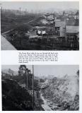 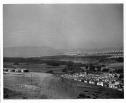 Date: 04/21/14 23:08 Re: OS RR Author: 2472Don Frank -
Thank you for all of your photos but especially #3... special because 1 year after this was shot, I was born and raised in a house in the Outer Sunset District which is in the center of that photograph. Don San Francisco, California Date: 04/22/14 12:34 Re: OS RR Author: anotherera Just got to love picture #3, especially if you grew up in Westlake, like I did. That little subdivision in the lower right of the picture is Broadmoor, and a new school was built adjacent to the OS right of way. The ROW was used as a horse trail to connect the stables in Colma to the trails at the beach in Westlake. I used to watch people riding horses right by the window of my classroom, when I should have been paying attention to the schoolwork. In fact, I've ridden that trail myself more than a few times. By the time I bought my own horse and kept it at the stables in Westlake, the trail was gone. Westlake Bowl backed up to it, and then the apartments came.
Date: 04/22/14 17:27 Re: OS RR Author: HB90MACH Before and after pics would be really interesting following this. Thank you for taking the time to post.
Date: 04/22/14 20:29 Re: OS RR Author: 2472Don HB90MACH Wrote:
------------------------------------------------------- > Before and after pics would be really interesting > following this. Thank you for taking the time to > post. I believe that those new houses on top of the hill in 1947 (in the foreground) are on what is now Louvaine Place... note that the street was not even complete with landscaping, etc. I believe that said photograph; showing Broadmoor on the lower right side, was shot from where the Seton Medical Center; formerly Mary's Help Hospital, stands now. My old-timer friend says it is called St. Francis Hill. Don San Francisco, California Edited 2 time(s). Last edit at 04/22/14 21:14 by 2472Don. |