| Home | Open Account | Help | 274 users online |
|
Member Login
Discussion
Media SharingHostingLibrarySite Info |
Nostalgia & History > Depot Friday, Portland, OR SouPac Red Car StationDate: 08/15/14 12:47 Depot Friday, Portland, OR SouPac Red Car Station Author: MartyBernard When we think about the Red Cars we remember the red electric cars of the Pacific Electric or the East Bay (Oakland/Berkeley). But Oregon had red cars that ran between Portland and Corvallis. They looked like the PE Blimps but were smaller. One exists at the Orange Empire Ry Museum but not in the public space. An overview of the interurban line with pictures of the cars and a map may be found at:
http://www.pdxhistory.com/html/red_electrics.html The depot picture below is from the Oregon Historical Society's Photograph Collection is of the Bertha Depot in 1932. I have searched for a location called Bertha with no luck. NEW VIADUCT CARRYING CAPITOL HIGH WAY OVER SO. PACIFIC RED ELECTRIC LINE TRACKS AT BERTHA STATION. [Graphic], 99/99/1932 Call Number: ORHI50113 Database: OCLC-MARC Bibliographic (OCLC) Enjoy, Marty Bernard Edited 1 time(s). Last edit at 08/15/14 12:49 by MartyBernard. 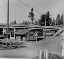 Date: 08/15/14 14:20 Re: Depot Friday, Portland, OR SouPac Red Car Station Author: sundance Bertha is where S W Capitol Highway goes over S W Multnomah Blvd in Multnomah Village S W Portland.
Date: 08/15/14 15:30 Re: Depot Friday, Portland, OR SouPac Red Car Station Author: Evan_Werkema MartyBernard Wrote:
> An overview of the interurban > line with pictures of the cars and a map may be > found at: > > http://www.pdxhistory.com/html/red_electrics.html A slightly wider version of the Bertha station photo is on that page about 2/3rds of the way down, and on this page with an explanation of the origin of the name: http://www.pdxhistory.com/html/southwest_hills.html sundance Wrote: > Bertha is where S W Capitol Highway goes over S W > Multnomah Blvd in Multnomah Village S W Portland. Old topo maps show the Oregon Electric following what is now Multnomah Blvd., with the SP line further to the north. There is still a Bertha Blvd. in the area following the SP electric right-of-way, and the Capitol Highway has an overpass spanning it. The overpass shows signs of having been widened since the interurban days, but this looks to be the spot: http://goo.gl/maps/j4UEk It is also where Bertha is marked on this 1927 map: http://www.historicmapworks.com/Map/US/1363532/Page+019+++Township+1+S++Range+1+E+++Portland++Fairvale++Somerset++Fulton+Park++Dewitt+Heights/ See also: http://www.waymarking.com/waymarks/WM3H5M_Red_Electric_Head_On_Collision_Bertha_Oregon http://multnomahhistorical.com/red-electric-wreck/ http://swtrails.org/2014/06/05/the-southern-pacifics-red-electrics-a-walkers-guide/ |