| Home | Open Account | Help | 278 users online |
|
Member Login
Discussion
Media SharingHostingLibrarySite Info |
Nostalgia & History > SP Los Gatos canyonDate: 10/30/14 21:55 SP Los Gatos canyon Author: fmaffei # 1 is just south of Los Gatos CA # 2 is just north of tunnel one [summit]
Santa Cruz mountains 1937 Will whitaker,A. Menke collection 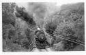 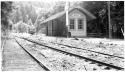 Date: 10/30/14 22:25 Re: SP Los Gatos canyon Author: coach Super wonderful post of a line no longer with us--rare photos are always great!
Date: 10/31/14 10:00 Re: SP Los Gatos canyon Author: sagehen Great photos! Thanks for posting.
In photo 1, the flume is visible toward the upper right of the picture. You can still see parts of it today from Highway 17 in the short section from Los Gatos to Lexington Dam. In photo 2, you can see that the line had an ABS system using lower quadrant semaphores. Stan Praisewater Date: 10/31/14 11:19 Re: SP Los Gatos canyon Author: sagehen rantoul Wrote:
------------------------------------------------------- > Where would these photo locations be relative to > today's Highway 17? Thanks In the first photo, Highway 17 would be just above the train and to the left. It's in the very short section of canyon between Los Gatos and the future Lexington Dam. The second photo is a couple of miles east of Highway 17 where the highway goes over the summit. Stan Edited 1 time(s). Last edit at 10/31/14 11:20 by sagehen. Date: 10/31/14 11:30 Re: SP Los Gatos canyon Author: 4451Puff On the Santa Cruz side of the mountain, along what is now the Santa Cruz Big Trees & Pacific ROW, there are several of the concrete semaphore foundations still in place.
Desmond Praetzel, "4451 Puff" Date: 11/01/14 10:04 Re: SP Los Gatos canyon Author: Stottman Not to hijack, but this is what the areas look like today.
Photo 1, Los Gatos creek canyon between the city of Los Gatos, and Lexington Res. Much of it is now a hiking trail. You can see the bridge remains. The original posters photo was taken about the bottom on the dam. Photo 2. Old ROW where the Wrights station was. While it would also make a nice hiking trail, it is owned by the water company and closed for some reason. I took this photo about were the bridge is in the original posters photo. Photo 3. Remains of the bridge at Wrights. The remains of the trestle piles are still in the ground (not pictured). 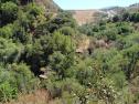 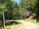 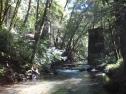 |