| Home | Open Account | Help | 274 users online |
|
Member Login
Discussion
Media SharingHostingLibrarySite Info |
Nostalgia & History > Obscure locations: Faith, South DakotaDate: 05/25/23 03:57 Obscure locations: Faith, South Dakota Author: tolland Here is another photo from the collection of the South Dakota Historical Society. I have been studying Milwaukee Road depots in various locations in South Dakota. Faith was the west terminus of a branch line that traversed several Native American reservations. There was a stockyard here and this beautiful Milwaukee Road depot. I don't know if this depot is still standing or not. Obviously, it was not a location of high traffic for the Milwaukee. The information on the photo does not give a date for the photo.
Jim Burrill Belle Fourche, SD. 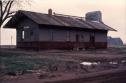 Date: 05/25/23 08:02 Re: Obscure locations: Faith, South Dakota Author: monaddave tolland Wrote:
<<don't know if this depot is still standing or not >> Google street view says it is; at the Faith Information Center, a "city government office"... https://goo.gl/maps/pEb6RoL75VubdoXV7 An earth view (satellite) shows a building attached to the back of it. Dave in MT Date: 05/25/23 12:02 Re: Obscure locations: Faith, South Dakota Author: billmeeker Thanks for posting this photo of such an obscure location on the MILW. As you said, Faith was at the end of a long branch line that featured many bridges and curves, unlike other branchline in the area. I have never seen photos of a train on this line. Faith is known as the location of the famous "Sue" Tyrannosaurus Rex skeleton found nearby.
Date: 05/26/23 07:55 Re: Obscure locations: Faith, South Dakota Author: RSD5 How was Faith reached? Difficult to find much information .
Dave Date: 05/26/23 21:32 Re: Obscure locations: Faith, South Dakota Author: billmeeker RSD5 Wrote:
------------------------------------------------------- > How was Faith reached? Difficult to find much > information . > > Dave The branch left the east-west main just west of Mobridge SD. You can follow it all the way to Faith (the line to Isabel split at Trail City) using Google satellite maps. Date: 05/27/23 14:34 Re: Obscure locations: Faith, South Dakota Author: XE-50W View looked ESE from about 50 ft. W-of grade-crossing on S side of U.S.№ 212/1ST St. E in NE part of town (site platted-by Milwaukee Land Co. in 1910). Agency closed c.1962, and original slide(?) taken about that time or w/in following decade. Original depot was an ‟extended style-D” type that arrived-on a truss-rod flat w/first train from Eagle Butte (42½ mi.E/b) in early Jan., 1911 – this (2nd) ‟style C” depot appears to have been constructed c.1914.
Passenger service was originally a Mon-Sat ‟mixed” supplanted w/a #59XX-series Express-coach gas-electric ‟motor” c.1927, when then-CMStP&P’s ‟motors” were converted-to diesel-electrics. Latter ran-as №’s 405 Tue-Thu-Sat, and 406 Mon-Wed-Fri trailing a rib-sided RPO-Express-coach ‟branchline combine” w/the ‟mixed” №’s 205 Mon-Wed-Fri, and 206 Tue-Thu-Sat. The ‟motor” last ran in late Jan., 1949. and was the last-such used in scheduled passenger service operated-on ‟Lines West” (of Mobridge). However, that ‟mixed” service continued w/passengers allowed to ride in the caboose into early 1955, when №’s 17 & 18 coach-only remnants of the ‟Columbian” were cut-back from Marmarth, ND to Aberdeen. Both grain and livestock (stockyards were ¼ mi.E/b from depot) were shipped-out, w/a considerable amount of wool as-well. A double warehouse for latter once stood W-of and across the tracks from the depot along S side of highway/1st St. E. Line abandoned-from Trail City (originally Cheyenne Jct., 106.1 mi.) in late 1978, w/tracks removed starting-in April of following year. Existing ‟Information Center” structure’s relocated some 300 ft. N across the highway/1st St. E, and rotated about 140° CCW w/30±ft. added to end seen above. Preceding information from MILW In Dakota by R.W. Mills, Battle Creek Pub.©1998 (has several historic b&w photos of RR, plus color shot of depot from the E in Faith), One Hundred Ghosts by B. Hatfield, Arrowhead Models ©2022 (ref.p.310, although it’s primarily about the 1910-1979 55 mi. Isabel branch from Moreau Jct. to the N), and PNR MILW employee timetable collection (ref. https://research.milwelectric.org/Employee_Timetables/Forms/AllItems.aspx). Also, an ‟all-time/maximum system” RR map of South Dakota originally published-by that state’s Transportation Dept. as part-of their 1989 statehood Centennial event is available ‟on-line” (ref. http://aberdeenareahistory.org/files/fullsize/bcab530c74ef98e29da5804430ccace0.jpg). Date: 07/21/23 15:54 Re: Obscure locations: Faith, South Dakota Author: rhburn3 Question for the group: My college girlfriend's mother was born in Dupree, SD, in 1910. In 1928, her parents sent her to Clarke College, a Catholics Girls School, Dubuque, IA. Roads were primitive that area in 1928. In my 1926 Official Guide, she would have left Dupree (3 stations east of Faith) at 10:50 am on Mixed Train 218 on the Milwaukee Road. That train was scheduled into Mobridge, SD at 6:30 pm, but how often did a mixed train arrive on time. My guess that she, (she probably also had a chaperone, mother, or nun with her) spent the night in a rooming house. The next day, they would have Mobridge at 9:30 Central Time on the "Olympian" for St. Paul arriving at 9:20 pm.
Tight Connections were normal in 1926 and the could have left St. Paul at 9:30 pm on the "North Coast Limited" on the Burlington to East Dubuque arriving at 4:08 am. The shuttle train over the Mississippi River bridge left at 4:15 am and would get into Dubuque at 4:25 am. Any thoughts on this comment. |