| Home | Open Account | Help | 354 users online |
|
Member Login
Discussion
Media SharingHostingLibrarySite Info |
Canadian Railroads > Here's One Way to Get in Your Own PictureDate: 01/15/19 19:09 Here's One Way to Get in Your Own Picture Author: cn6218 120 had trouble getting out of Moncton yesterday. Apparently there were problems with the air, and they left behind part of the train before departing around noon with only 416 axles. I was late getting out of town myself, but it looked like I might be able to meet them at Folly Lake, where they would have a meet with 407 (also late for some reason). I was hoping for a shot of both sets of power at the west end of the siding, but was a few minutes late for that, and instead went for the tried and true broadside near the east end of the lake (not shown here) at 14:33.
Then it was off to Baseline Road (ice covered dirt road - look out!) and the Bailey Bridge shot. Because the track is down in a bit of a cut, this location only works in the afternoon when the sun lights it up. It's usually a good bet in the summertime for the Ocean, and it worked out well for 120 at 14:39. The only problem was that I still had the 50mm lens on the camera from the previous location. I would usually have gone with something like the 85 or even longer here, but there wasn't time to change. I was going to crop it, but decided I liked the shadow of the latice work (and me) at the bottom of the frame. The train now had to loop out to Londonderry before turning east again, so I was able to go back the way I had come and get to the East Mines trestle for a broadside at 14:47. This view has only been possible for the past year or so after somebody cleared all the scrubby trees off the field in the foreground. I don't know what they have planned for it, but out here, it's not likely to be condos! I had enjoyed clear skies on Folly Mountain, but ran into some cirrus cloud as I neared Halifax on the way back. The cloud, combined with the setting sun, meant the light was down a full three stops by the time I got the final shot of the day at 16:18, as 120 passed Bedford Quarry. As it turned out, the crew didn't even make it all the way to Rockingham. A relief crew was waiting for them at mile 7, but by then the sun was gone and so was I. GTD 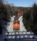 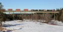 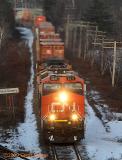 Date: 01/16/19 05:15 Re: Here's One Way to Get in Your Own Picture Author: refarkas First-rate images. You are right about the bridge shadow with you there also. Very creative not to crop the shadow out.
Bob Date: 01/17/19 06:25 Re: Here's One Way to Get in Your Own Picture Author: pummer Good stuff, as usual. I really like the bridge shot.
Date: 01/17/19 12:09 Re: Here's One Way to Get in Your Own Picture Author: feclark Somebody certainly has done you a favour with the bridge location. It's stunning to be that close to water, that far back from the trestle, and have no trees killing the shot. Nice.
Fred Date: 01/17/19 12:25 Re: Here's One Way to Get in Your Own Picture Author: ns1000 Nice pics!!
Date: 01/17/19 17:24 Re: Here's One Way to Get in Your Own Picture Author: cn6218 feclark Wrote:
------------------------------------------------------- > It's stunning to be that close to > water, that far back from the trestle, and have no > trees killing the shot Uncommon here, but standard fare out west where you are, isn't it Fred? GTD Date: 01/18/19 23:22 Re: Here's One Way to Get in Your Own Picture Author: feclark cn6218 Wrote:
------------------------------------------------------- > feclark Wrote: > -------------------------------------------------- > ----- > > It's stunning to be that close to > > water, that far back from the trestle, and have > no > > trees killing the shot > > Uncommon here, but standard fare out west where > you are, isn't it Fred? > > GTD I don't know if this is an innocent question, or as I suspect, you're having some sport at my expense. Bridges mean water, and water means trees, and those suckers grow quickly and engulf a bank pretty much in a few years. It'd take me too much to dig out the links, but the trestle over the Pembina River at Entwistle, or the one between Hinton and Entrance (my mind's blanked on the river), and even Fabyan have real limits on where you can set up a clean shot, and believe me, it's not distant broadside. Maybe SK and MB are different, but those poplars are tenacious and fast. Fred Date: 01/19/19 07:51 Re: Here's One Way to Get in Your Own Picture Author: cn6218 feclark Wrote:
> I don't know if this is an innocent question, or > as I suspect, you're having some sport at my > expense. Bridges mean water, and water means > trees, and those suckers grow quickly and engulf a > bank pretty much in a few years. No, just an innocent question. In the east, trees grow EVERYWHERE! There isn't really much difference whether they are close to water or not. In the particular example of the East Mines trestle, the Folly River flows under the east end, the old highway is under the west end, and the meadow between was a hay field or something before it all became overgrown in the last 20 years. I should dig out some slides from back then as a comparison and make a postuing out of it some time this winter. I wasn't quite sure what your water reference was all about, since you can't really see the [frozen] river in my most recent picture. When the place was all grown in, about the only broadside view was looking up the highway on the left, or straight up the river on the right, but that includes only a very small part of the trestle. GTD Date: 01/19/19 19:16 Re: Here's One Way to Get in Your Own Picture Author: feclark cn6218 Wrote:
------------------------------------------------------- > feclark Wrote: > > I don't know if this is an innocent question, > or > > as I suspect, you're having some sport at my > > expense. Bridges mean water, and water means > > trees, and those suckers grow quickly and engulf > a > > bank pretty much in a few years. > > No, just an innocent question. > > In the east, trees grow EVERYWHERE! There isn't > really much difference whether they are close to > water or not. > > In the particular example of the East Mines > trestle, the Folly River flows under the east end, > the old highway is under the west end, and the > meadow between was a hay field or something before > it all became overgrown in the last 20 years. I > should dig out some slides from back then as a > comparison and make a postuing out of it some time > this winter. > > I wasn't quite sure what your water reference was > all about, since you can't really see the river > in my most recent picture. When the place was > all grown in, about the only broadside view was > looking up the highway on the left, or straight up > the river on the right, but that includes only a > very small part of the trestle. > > GTD I thought I saw the indications of a frozen-over river on the right side of the shot; ice is water, no? Anyway, trees love to hang out near the rivers here, when all around things may be flat land, mostly fields. It took poplars something like 6 years to wipe out most of the west slope views of the trestle at Fabyan, for example. At any rate, this discussion tends to make us lose track of the main point, which is that your shot is gorgeous, and the location spectacular. Fred |