| Home | Open Account | Help | 345 users online |
|
Member Login
Discussion
Media SharingHostingLibrarySite Info |
Canadian Railroads > CN 5096 a mile east of Yellowhead 1973Date: 10/25/19 15:49 CN 5096 a mile east of Yellowhead 1973 Author: photobob Here's a shot i took durng my cross Canada trip in 1973.
Robert Morris Dunsmuir, CA Robert Morris Photography 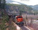 Date: 10/25/19 16:24 Re: CN 5096 a mile east of Yellowhead 1973 Author: hoggerdoug Nice image. What is the second unit, leased C&O ???
Doug Date: 10/25/19 16:35 Re: CN 5096 a mile east of Yellowhead 1973 Author: TCnR Looks like Dunsmuir.
Date: 10/25/19 18:01 Re: CN 5096 a mile east of Yellowhead 1973 Author: BoostedFridge What a fantastic image! The slide seems to have withstood the test of time quite well
Date: 10/25/19 18:06 Re: CN 5096 a mile east of Yellowhead 1973 Author: photobob It was not from a slide but 120 Ektacolor negative film shot with a Bronica S medium format camera. All of my fifty year plus color negatives are as good as the day I shot them.
Robert Morris Dunsmuir, CA Robert Morris Photography Date: 10/25/19 19:37 Re: CN 5096 a mile east of Yellowhead 1973 Author: feclark Stellar shot; also nice that the trees are relatively constrained, so you can see what's in the distance.
Fred Date: 10/25/19 20:39 Re: CN 5096 a mile east of Yellowhead 1973 Author: eminence_grise Yellowhead has been double tracked since the 1980's and I suspect the curvature is changed. Yellowhead is CN's crossing of the Continental Divide, also the border between BC and Alberta, and Jasper National Park and Mount Robson Provincial Park. It is also the boundary of Pacific and Mountain time zones.
Until WW1, there were two railways over the Yellowhead Pass, the Grand Trunk Pacific which is usually the current CN main, and the Canadian Northern, on which Highway 16 is built or is close by. The GTP had to build around the big rock bluff behind the train, however the CNor and the present highway pass behind it in a brief but narrow canyon. There is a public crossing over the current CN line right at the Continental Divide which provides access to hiking trails. |