| Home | Open Account | Help | 259 users online |
|
Member Login
Discussion
Media SharingHostingLibrarySite Info |
European Railroad Discussion > Porto, Portugal mystery trackageDate: 01/13/23 22:24 Porto, Portugal mystery trackage Author: stormhighway1 In Porto, Portugal, there is an abandoned rail line that runs halfway down the cliff from the current active mainline on the north side of the Douro River. To the east, this abandoned trackage moves upgrade and merges with the current mainline.
This ROW seemingly dead-ends or enters a tunnel at this location, then the ROW is no longer visible to the west: https://www.google.com/maps/place/Bonfim,+Porto,+Portugal/@41.142185,-8.601897,177m/data=!3m1!1e3!4m13!1m7!3m6!1s0xd2465abc4e153c1:0xa648d95640b114bc!2sPorto,+Portugal!3b1!8m2!3d41.1579438!4d-8.6291053!3m4!1s0xd2464f2dfcdb60d:0x500ebbde4904410!8m2!3d41.1510153!4d-8.5940618 I can't tell if there is a tunnel here that leads to a mid-town station (like the mainline does, to Sao Bento station) or if the line actually dead-ends here. There are ruins of what looks like some type of station or industrial building just to the west of where the ROW is no longer visible. Does this old line continue to the east in a tunnel, descend to the water-level, or just dead-end? Google is no help in solving this mystery, and none of the street view angles show what is there pas that point. Date: 01/14/23 06:01 Re: Porto, Portugal mystery trackage Author: mexrail Click on this link, https://www.openrailwaymap.org/. Then type Porto in search box. It will give you many option stations to choose from. Click on Porto - Campanha. That will bring up the area you see on Goggle. You will see the dashed lines indicating the abandoned former main line south to Lisbon. It appears tracks are still in place on the beautiful Dona-Maria-Pia bridge. That should answer most of your questions as you can zoom in for more detail. I plan to be in Porto in April, arriving from Lisbon by train.....of course!
Mexrail Date: 01/14/23 19:19 Re: Porto, Portugal mystery trackage Author: Steinzeit2 This was a branch that left the main line just to the north of Campanha station and, descending, passed to the east of the station, went under the main line in a tunnel, was visible for a short stretch, and then continued in a tunnel most of the way to a riverside freight station located on R. Nova de Alfandego, about where the parking lot on the east side of the Transportation Museum is currently located.
SZ Edited to add this photo, taken in 1973. I am standing near the north end of the old [ 1877 Eiffel ] bridge looking downstream, and you can see the branch at the bottom right and right center of the photo.; I did not go down to that freight station area. Edited 1 time(s). Last edit at 01/14/23 19:33 by Steinzeit2. 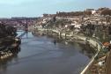 Date: 01/15/23 02:50 Re: Porto, Portugal mystery trackage Author: 86235 Today's Railways Europe Jan 2023 has a whole feature about the railway scene in Porto including a picture of the abandoned right of way to Porto-Alfândega.
Edited 1 time(s). Last edit at 01/15/23 02:51 by 86235. Date: 01/15/23 03:05 Re: Porto, Portugal mystery trackage Author: stormhighway1 Thank you for the excellent information! Is the western portal of the tunnel visible anywhere?
Date: 01/15/23 16:55 Re: Porto, Portugal mystery trackage Author: Steinzeit2 stormhighway1 Wrote: ...... Is the
> western portal of the tunnel visible anywhere? Possibly. The trackage exited the tunnel through a wall at 'car park level' below the street at an approximately 20 deg angle at a location roughly opposite where today the dock and office of the Maritime Police are located. I have been unable to find on the internet a recent view of this location from ground level; for some unfathomable reason all the photographs taken here seem to show scenic views along or across the river instead of a wall possibly covered in ivy -- what is wrong with these people.... So it is not clear what evidence of that exit remains. Because the section was steam worked one might think there would be some ventilation and possible emergency exits from the tunnel; I notice in the grassy triangle of land formed by the intersection of Infante and Rua da Reboleira, opposite the reversing section for today's tram, that there are some short circular structures, like cupolas, that might, or might not, be examples. To the right of the tunnel exit there was a short "shunting neck" in the sideways U space formed by the ramp leading from the street to track level. It seems rather short to have been of much benefit, so perhaps its purpose was to allow locomotives to couple to the head end of up trains without entering the tunnel and otherwise run round. I hope that answers your question. With best regards, SZ |