| Home | Open Account | Help | 354 users online |
|
Member Login
Discussion
Media SharingHostingLibrarySite Info |
Railroaders' Nostalgia > Mad Dog Chronicles # 163 Track Chart page for Scotia BlDate: 02/04/06 07:05 Mad Dog Chronicles # 163 Track Chart page for Scotia Bl Author: mdo The worst spot on the North end of the NWP was Scotia Bluffs. They never quit trying to fall into the Eel River.
2/4/06 mdo 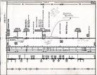 Date: 02/04/06 07:12 Re: Mad Dog Chronicles # 163 Track Chart page for Scoti Author: mdo Notes for page 742
 Date: 02/04/06 07:13 Re: Mad Dog Chronicles # 163 Track Chart page for Scoti Author: mdo second page of notes for page 742
 Date: 02/04/06 07:14 Re: Mad Dog Chronicles # 163 Track Chart page for Scoti Author: mdo page three
 Date: 02/04/06 07:17 Re: Mad Dog Chronicles # 163 Track Chart page for Scoti Author: mdo Page four of the notes on Scotia Bluffs.
As Tony J has already pointed out, restoreing the North end of the NWP will be a never ending task. 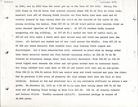 Date: 02/04/06 08:13 Re: Mad Dog Chronicles # 163 Track Chart page for Scoti Author: WAF When you see the Bluffs from the Scotia side of the river, you can understand why this is a constant problem to the NWP. Almost a vertical hillside that is bare. A shovel and cat were stationed at the bluffs to clear debris. The railroad went across Manning Creek trestle and did allow some debris to fall under the bridge pilings and the hillside. During the winter of 81-82, if the NWP was closed, Scotia Bluffs was the culprit half the time.
Date: 02/04/06 08:17 Correction Author: WAF Nanning Creek...
Date: 02/04/06 08:32 Flood of 1964 Author: WAF If you are ever in the Redwood Country along US 101, get off at South Fork and drive the frontage road. You will see the High Water Markers from 1964 along the road. I'm sure the Russian River area has similar markers.
Date: 02/04/06 09:28 Re: Flood of 1964 Author: stash WAF Wrote:
------------------------------------------------------- > If you are ever in the Redwood Country along US > 101, get off at South Fork and drive the frontage > road. You will see the High Water Markers from > 1964 along the road. I'm sure the Russian River > area has similar markers. If you tour the PALCO mill, there are high water markers inside the building. Date: 02/04/06 10:06 Photo of Scotia Bluffs Author: photobob Heres a shot I took back in 1962 of the Scotia Bluffs with NWP's Eureka bound RDC.
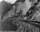 Date: 02/04/06 10:14 Re: Photo of Scotia Bluffs Author: WAF That pretty much describes it, Bob. Do you have any from across the river showing the Bluff's height?
Date: 02/04/06 11:01 Re: Photo of Scotia Bluffs Author: mdo Further proof that Black and White photography is not boreing. A very nice shot Bob.
Date: 02/04/06 14:55 Re: Photo of Scotia Bluffs Author: SierraRail Pacific Lumber Baldwin road-switcher #105 along Scotia Bluffs, 1968.
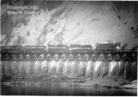 Date: 02/04/06 15:23 Re: Photo of Scotia Bluffs Author: WAF That's the angle I wanted to see
Date: 02/06/06 06:08 Re: Mad Dog Chronicles # 163 Track Chart page for Scoti Author: BCHellman If the Bluffs were such a problem, as documented here, why didn't they relocate the railroad on the opposite bank of the river?
1964 must have been a bad year for the area. Wasn't this the same year as the Alaskan earthquake that caused the Tsunami that hammered Crescent City? Date: 02/06/06 07:23 Re: Mad Dog Chronicles # 163 Track Chart page for Scoti Author: WAF April was the Alaskan quake and the floods were days before Christmas, so yeah, it was a year of Mother Nature's wrath.
|