| Home | Open Account | Help | 371 users online |
|
Member Login
Discussion
Media SharingHostingLibrarySite Info |
Railroaders' Nostalgia > Tuesday Track & Time: Weather Data, Sacate, Grimes CynDate: 04/14/14 21:58 Tuesday Track & Time: Weather Data, Sacate, Grimes Cyn Author: railstiesballast SP Coast Line Weather and Washouts
Here is a little weather data to help understand the washouts along the SP coast line in 1978 that have been the subject of several posts. The prior years were quite dry and the ground cover was weak due to grass not sprouting, grazing, and possibly some fires. The 19777-78 “water year” was very wet. In contemporary terms we would call this an “El Nino” event. I picked up data for three weather reporting sites in Santa Barbara county that document what we all went through that winter and spring. The first number after each site is the annual average, the second number is the 76-77 water year, and the third number is the 77-78 water year. Lompoc is inland about 10 miles inland from Surf, to represent weather north of Point Conception, Lake Cachuma is about 20 miles north of Santa Barbara and represents rainfall in the coast mountains, and Santa Barbara is east of Point Conception along the coast. Lompoc: 16.0” 10.1” 28.2” Lake Cachuma: 22.1” 16.0” 40.7” Santa Barbara: 17.7” 14.9” 42.34” No wonder the rivers ran high and the ground got soft and slid away! Here is an image of a slide at Sacate, about half way between Gaviota (where Highway 101 turns inland and the SP continues westward along the coast). The RR is up on a bluff here. The supporting ground is very steeply dipping strata of very young and moderately weak siltstone. In the 1920s the SP constructed seawalls along the bottom of the bluffs to stop erosion of this weak rock. Where the rock is undercut by the surf, chunks fall down. Sacate was a 5114’ siding inland from the main track. When the ground dropped away right up to the end of ties at the east switch we immediately began running trains via the siding. After some weeks of that we picked up the siding track in the slide area and shifted the main track over to the siding alignment where it remains. For a while we left the remnant of the siding in place as a MofW spur but eventually it was removed. In order to guard against running a train off into a void from a future slide we installed a form of tilt sensors that activate the signal system if the ground moves. I can’t locate more pictures of Sacate right now. At Grimes Canyon, Milepost 423.94, west of Moorpark, both the SP and the highway bridges washed out. This was due to the failure of an SP-owned “drop structure” where Grimes Canyon flowed into the Arroyo Simi, the main river from Simi Valley to the ocean. Arroyo Simi had cut down several feet and when Grimes canyon scoured its channel down to meet it, it undercut the bridges. The highway patrol had a roadblock set up but for some reason they let a local driver through and he went off to his death in the hole, another mystery to me how and why that happened. Our first response was to put some metal pipes into the hole and backfill them. The massive concrete abutments of the original bridge were a challenge to route the pipes and to drive piling for the permanent bridge. As it happened we had the SPMW 5595 with Russell Glenn as pile driver engineer trapped behind the washout so we used him to lift up the swinging track so we could get more dirt into the hole. Over the next few months we drove piling and set three 30-foot precast concrete box girder spans. I have to confess to an error at Grimes Canyon. Remembering the use we made of scrap cars to protect the Great Salt Lake Fill and seeing how much rip-rap we needed, I arranged for a scrap 50-foot flat car to be placed in the right of way ditch upstream and east of the new bridge. It simply didn’t work, it rested on top of buried rip-rap stone and we had to haul it off a few months later. My loyal Bridge and Building Supervisor, Guy Sanders, reversed this situation for me on his own initiative as I was too proud to fess up at the time. The images: Sacate from the air. Grimes Canyon, totally washed out Grimes Canyon, pipes set. 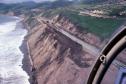 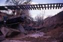 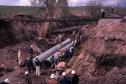 Date: 04/14/14 21:52 Tuesday Track & Time: More Grimes Canyon Pix Author: railstiesballast Grimes Canyon, pushing dirt in.
Grimes Canyon, filling the hole through the night Driving piling for the new bridge. 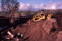 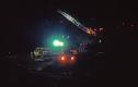 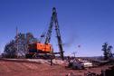 Date: 04/14/14 23:29 Re: Tuesday Track & Time: More Grimes Canyon Pix Author: bradleymckay Mike: Both the winter of 1976-1977 (dry) and the winter of 1977-1978 (wet) were considered weak El Nino years.
Take a look at this chart: http://ggweather.com/enso/oni.htm Allen Date: 04/15/14 01:50 Re: Tuesday Track & Time: More Grimes Canyon Pix Author: sliderslider This is a stupid question: why did you put pipes int he hole at Grimes Canyon? Why did they build the original bridge with footings that could be undercut by the failing of the drop structure? Was the drop structure built specificially to protect the bridges after the creek they fed into downcut?
Date: 04/15/14 10:24 Re: Tuesday Track & Time: More Grimes Canyon Pix Author: usmc1401 Rain in San Luis Obispo at Cal Poly in 1977-1978 winter was 65 or 70 inches of rain on campus.
Date: 04/15/14 10:28 Re: Tuesday Track & Time: More Grimes Canyon Pix Author: railstiesballast The pipes were put in to temporarily take an average storm discharge. It takes weeks or months to get the material for a bridge on hand and several days to drive the piling. The superstructure can be erected in one day. But we had many locations and no certainty that we would not have a worse problem elsewhere so the temporary, quick repair (about 24 hours) was the best option.
When the SP built through the valley in the 1900s the bridge was a good match to the amount of water flowing in the creek and the profile of the creek and the river. In later decades the river (Arroyo Simi) cut down into its channel and the drop structure was built to stabilize the tributary stream's profile. IIRC the drop structure washed out in one big storm and about a week later the next big storm washed out the Grimes Canyon bridges. I don't know if anyone on the SP even knew of the loss of the drop structure when it happened, we were all off chasing washouts and struggling to run trains. I have seen channels deeply erode several places including Newhall (where we lost the Santa Paula Branch bridge this same year) and San Juan Capistrano on the Santa Fe Surf line. In all cases the infrastructure that matched the late 1800s early 1900s hydrology simply could not be adjusted to the changes over the decades. The flowline of a stream is a dynamic thing. It is the "snapshot" of the river's load of silt, sand, and gravel at the moment you see it. During any significant flows the alluvial material is moving along the bottom of the channel. The sand you see now is not the same sand you saw last year or will see next year at the same location, the individual grains are always moving downstream. It is my opinion that years with a lot of bare ground for erosion as with fresh land clearing or wildfires the streambed gets filled up with alluvial material; in years with less erosion, or after channels are lined with concrete and land paved over, there is insufficient alluvial material to replace what is washed downstream and the flowline is cut down. Hydrologists, please advise me an TO readers if this idea is correct or not. Date: 04/15/14 11:30 Re: Tuesday Track & Time: More Grimes Canyon Pix Author: GP30Frank AS usual, another fine explanation. I'm NOT a trained engineer, as you are, and some of this is "over my head", but I still enjoy reading about it.
Frank, in Tennessee Date: 04/15/14 11:51 Re: Tuesday Track & Time: More Grimes Canyon Pix Author: BCHellman What's a drop structure?
Date: 04/15/14 12:22 Re: Tuesday Track & Time: More Grimes Canyon Pix Author: spnudge I learned about a creek finding its own level that year. My grand parents had a ranch in Goleta since the mid 30s, My Aunt Kitty Bishop had a ranch at Coromar (MP 360) and TM Storke, my uncles father had a place where UCSB is now.
Part of the property line at our place was San Pedro Creek. This creek came from the Santa Ynez mountains, and went to the ocean near the airport. It went under the SP at the west switch at Goleta. I was working a work train out of SLO when I got a message to call home in Atascadero. It was the foreman on the ranch in Goleta saying we had lost our bridge over San Perdro Creek. I remembered when I was about 8 and they put in this new bridge with concrete sides and base and new timbers, and it was paved 6 months later. How could we have lost our bridge? The foreman put a temporary road down through one of the orchard rows so we could get in and out on a stub of Cathedral Oaks Rd. (That bridge wouldn't be built for awhile) The railroad shut down a day or so later to fix all the damage up and down the Coast. A bunch of us went up to South Shore and stayed at a guys cabin that was a switchman in Wat. Jct. A nice winter break. Jump ahead a few months and I had some time to go to the ranch and see what the problem was with the bridge. I was given a crash course on water hydraulics, creeks, rivers, pipe & wire revetment, you name it. Well, it turned out what happened was right along with what was described by our engineer in the above thread. That previous summer, Santa Barbara county replaced the bridge on Stowe Canyon Rd over San Pedro Creek. I know I didn't think anything about it. Well, long story short, a creek, river, etc. will seek its own level, if changed at all. Like rebuilding a bridge. It turned out that the bottom of the Stowe Canyon bridge was about 16 to 24 inches lower than it should have been. Well, nature being what it is, the river repaired itself. It lowered the creek bottom from the Stowe Canyon bridge, back towards the mountains. In doing so it undermined our bridge and all that concrete. That let the structure become unsafe. The crowning blow was the county came in with a DH-K and started over the bridge. That finished her. The county knew they were hanging out a mile for what they had done about a 1/2 mile down stream. They built a 2 stage check dam and put in pipe and wire revetment for the sides. After the next winter, they re-built our bridge. The floor of the creek had not moved. I know the east end of Sacate was a challange for the MofW. The main line was 60 mph to the left hand curve beyond the east switch. Then it dropped down to 40 mph. It was a reverse curve going into a right hand curve and then right out on a bridge. It was 60 from there to Gaviota. Keep the stories coming. Its nice to see "the rest of the story" as Paul would say. Nudge Edited 2 time(s). Last edit at 04/15/14 12:39 by spnudge. Date: 04/15/14 13:27 Re: Tuesday Track & Time: More Grimes Canyon Pix Author: xrds72 To help clarify RTB's comments above about stream behavior, the characteristics of the water entering the system has a lot to do with it. For example, one thing that has hurt a lot of railroad structures in the placement of a dam upstream from their bridge which now controls the flow through the bridge.
Behind the dam the water slows down and whatever sediment is has been carrying settles out. When a storm comes the dam operator (often the Army Corps of Engineers such as on the Missouri River) will let water out to be able to absorb the expected increase of incoming water. The released water has no sediment to speak of and is "hungry". Moving water can and will transport sediment, the faster it is moving, the more it can carry. Now let's look at the railroad bridge just downstream from that dam. Over most of it's 100+ year life the stream has been relatively stable and calm. now, with the dam releasing sudden, high volumes of "clear" water, guess where that water is going to start picking up sediment to carry? This is an example of what RTB is referring to when he notes how fast a bridge can be washed out in a storm. Once the water starts to dig our the stream bed material, dig holes around the piers and piles and start to undermine them, a bridge can be in danger quickly. There are many other mechanisms going on here which contribute, but that gets into fancy math to calculate. Suffice it to say, watch out what happens up stream of a bridge (development can change the amount of runoff and how quickly it happens) and downstream (the highway department can replace a box culvert and release a restriction and allow a lowering of teh stream bed to move upstream and take out your bridge as happened to Amtrak at Kingman AZ in 1997) Date: 04/17/14 11:20 Re: Tuesday Track & Time: More Grimes Canyon Pix Author: railstiesballast Trainorders is a great place!
I learn a lot from the questions and answers from all the readers on these threads, thanks for participating. As to "What is a Drop Structure?", it is something in the channel that will let the flow line drop rapidly without eroding the channel. The most visible drop structures are dam spillways, they can take the whole river flow and drop it the full height of the dam without erosion damage. Most drop structures in streams or flood control channels are simple steps of a few feet that have strong channel lining, particularly downstream, where turbulence from the falling water would otherwise erode the channel bottom, and side reinforcement to prevent the flow from going around the drop structure. I should have explained that better, an example is in the image. Here is the sad end of the Santa Paula branch bridge over Newhall Creek at Saugus in March of 78. In the shadows on the far side you can see the SP's attempt to build and maintain a drop structure immediately downstream from the bridge. It was large rock, chunks of concrete, and mass poured concrete slurry, not a proper dam or standard drop structure, it was just to resist erosion. It worked for a decade or more. This drop structure failed letting Newhall Creek undermine the bridge. The big pile of drift against the piling on the far side of the washout is evidence of the depth of the flow before the washout. The bridge was never replaced, we let Los Angeles County Flood Control District deal with the rest of the channel. Where the main line crossed Newhall Creek a couple of miles to the south the stream was much smaller and we had the highway bridge downstream that slowed flows enough. Here the stream dynamics were that the Santa Clara River, about 4800 feet downstream to the left, had eroded its channel down by several feet and Newhall Creek had to erode down to that level as is sought its own new flowline. I don't have many pictures of this situation and had not planned on making a separate TT&T post about it. I took my photos where we were working to repair active main lines and just did not have time to spend here other than to come to an understanding of the Roadmaster's reports. Edited 1 time(s). Last edit at 04/17/14 11:21 by railstiesballast. 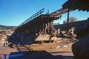 Date: 04/18/14 15:38 Re: Tuesday Track & Time: More Grimes Canyon Pix Author: SanJoaquinEngr I was on a train from LA to Bakersfield the day that the bridge washed out.. It was a rainy cold and snowy day in Santa Clarita. The lead unit was a SP 8800 and the engine keep dying enroute. At that time the engine heaters were not electric but ran on the hot colling water that was circulating from the engine block.. Without the unit running it was a matter of time before the engine became unbearably cold.. I made the decision to 'wye" the power at Saugus.. and the stem of the wye was the bridge and the east and west legs were all on solid ground.. This particular day I repeat was extremely rainy and the water was rushing under the bridge at a tremendous rate.. I ran the four units onto the bridge was it was vibrating and I told my head brakeman get me off this bridge ASAP it was going to collapse !! The next day came thru on an eastbound and the bridge section was gone ! Am thankful it did not collapse with me on it !!
Date: 04/21/14 13:51 Re: Tuesday Track & Time: More Grimes Canyon Pix Author: mwbridgwater Wow, Jim, that's a great story. Good thing for the 8800 as well, since it had the opportunity to be preserved at the Utah State Railroad Museum as SP's first SD45.
Mark Edited 1 time(s). Last edit at 04/21/14 13:54 by mwbridgwater. Date: 04/21/14 19:00 Re: Tuesday Track & Time: More Grimes Canyon Pix Author: SanJoaquinEngr mwbridgwater Wrote:
------------------------------------------------------- > Wow, Jim, that's a great story. Good thing for > the 8800 as well, since it had the opportunity to > be preserved at the Utah State Railroad Museum as > SP's first SD45. > > Mark Hey Mark what I meant to write was an 8800 series engine... might of been an 8900 .. original SD-45... Date: 04/21/14 22:09 Re: Tuesday Track & Time: More Grimes Canyon Pix Author: mwbridgwater Ahh, I should have read more carefully... now I see you did write "was a SP 8800".
Mark |