| Home | Open Account | Help | 348 users online |
|
Member Login
Discussion
Media SharingHostingLibrarySite Info |
Eastern Railroad Discussion > Triple Crossing near Blackstone, MADate: 08/29/11 19:55 Triple Crossing near Blackstone, MA Author: funnelfan While exploring southeast of Boston on aerial imagery, I came across this former triple railroad crossing just west of Blackstone, MA very near the Rhode Island state line;
http://mapper.acme.com/?ll=42.02013,-71.56756&z=15&t=T I was wondering if there are any photos of this triple crossing. Looks like there is only one active railway and two of the three bridges left today. Ted Curphey Ontario, OR Date: 08/29/11 20:32 Re: Triple Crossing near Blackstone, MA Author: wlankenau Interesting! The SPV Atlas shows the line from upper left to lower right as the Providence & Worcester, while the line that parallels it on the south side of the river and then crosses to the north side is ex-New Haven (New York & New England). The twisting "old railroad grade" isn't shown, however. I wonder if it might have been the original New Haven alignment? If you follow that line to the other side of Blackstone, it points right at the abandoned New Haven route. A look at the Mapquest satellite photo still shows evidence of that line.
SPV shows yet another railroad in that vicinity -- the Worcester Consolidated Street Railway, which seems to follow the alignment of highway 122. Date: 08/29/11 22:08 Re: Triple Crossing near Blackstone, MA Author: funnelfan Well the twisty old line crossed over the New Haven just east of Blackstone, but you lose it just south of there entering Woonsocket. It possibly may have wrapped around the hill to the east and joined the old line heading northeast out of Woonsocket, but hard to say. I'm sure it's not a realignment of the New Haven as those two lines parallel each other quite a ways to the west. I was able to follow the line to where it looped into the northeast side of Webster seen here as a fill crossing a creek;
http://mapper.acme.com/?ll=42.07077,-71.85350&z=16&t=T Edit; Looking closely again, I saw how the line passed along the north and west side of Webster and was able to follow the line into Southbridge where I lost it. Here is a section of the line west of Webster (the abandoned line) http://mapper.acme.com/?ll=42.03345,-71.94564&z=15&t=T Ted Curphey Ontario, OR Edited 1 time(s). Last edit at 08/29/11 22:17 by funnelfan. Date: 08/29/11 22:38 Re: Triple Crossing near Blackstone, MA Author: funnelfan Looks like the two main railroads were there by 1886, but the third one came later;
http://docs.unh.edu/MA/bkst95se.jpg And it was gone by 1943; http://docs.unh.edu/MA/blak44sw.jpg I don't get this, the line seems to end into a hillside in Woonsocket. The line heading NE out of town was also abandoned by that point, and I wonder if the two were related; http://docs.unh.edu/MA/blak44se.jpg Ted Curphey Ontario, OR Edited 2 time(s). Last edit at 08/29/11 22:46 by funnelfan. Date: 08/30/11 04:38 Re: Triple Crossing near Blackstone, MA Author: prr4828 funnelfan Wrote:
------------------------------------------------------- > I was wondering if there are any photos of this > triple crossing. Looks like there is only one > active railway and two of the three bridges left > today. I can shed some light on your discovery ... your mystery route is the Titanic Railroad ... otherwise known as the Southern New England, the Grand Trunk's never completed route to an ice-free port at Providence, RI. Photo 01: An annotated overlay of the site, with callouts of the railroads. If the text isn't visible, let me me know, I can post a larger version on the net with a link. Photo 02: View from Level 0, the active Providence & Worcester looking towards Worcester (geo:north/rr:west). Photo 03: Another view from the P&W, looking toward Providence (geo:south / rr:east) 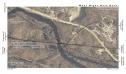 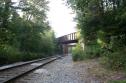 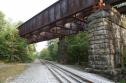 Date: 08/30/11 04:46 Re: Triple Crossing near Blackstone, MA Author: prr4828 Photo 04: Looking towards Worcester again, the P&W's bridge over the Blackstone River.
Photo 05: A downstream view of the P&W bridge, with the abandoned NH Midland Div bridge behind it. Providence is left, Worcester Right. Photo 06: On Level 1 now. This is the ex-NH Midland Div looking RR East. In the steam era, this route was double tracked. There were parallel pin connected deck trusses here. The through girder in the background was jacked up to allow autoracks to operate on the P&W. 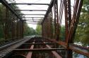 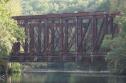 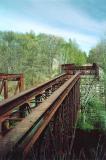 Date: 08/30/11 05:09 Re: Triple Crossing near Blackstone, MA Author: prr4828 And the ghost story:
This route was to have provided the Grand Trunk Western (of Canada) with an ice-free port in Providence, RI. Unfortunately, the road's president, Charles M. Hayes, had the misfortune to book passage back to US on the RMS Titanic. The route graded and abutments poured after his death. The route might've been completed had WWI not occurred. For further reading on the Southern New England, check out "Titanic Railroad" by Larry Lownthal: http://www.branchlinepress.com/catalog/Lowenthal_TitanicRR_0-9662736-0-5.html The book tells how the fortunes of the SNE rose and fell and the gravitational pull of the New Haven RR and other luminaries. Many construction photos illustrate the text and maps relate the route to is surroundings. IMHO: I rode a MassBayRRE Archeology Tour narrated by author Lowenthal. If the route in Mass was operable today, it *would* be a tourist/dinner train route! Photo 07: On Level 2: the abandoned Southern New England RR looking toward Providence. The (RR) west abutment and the main pier can be seen. Between these points would've stood two steel towers (paired bents?). The NH Midland Bridge is dimly visible through the trees, with Putnam left and Readville right. The next two photos look RR west along the SNE alignment. Photo 08: The main pier of the SNE's Blackstone River crossing. The P&W is in the foreground and the NH Midland out of frame below. Photo 09: From the RR east abutment of the SNE, with the main pier beyond. An intermediate pier is out of view below. The NH Midland is to the right, and the P&W is below the through girders of the NH Bridge. Personally, I'd like to clearcut and landscape the area ... but the homeowner behind me in Photo 09 might not like having to look at all that spoiled concrete and rusty steel! If I mixed up some details, let me know! If anyone knowledgeable about bridge design is still reading ... what kind of bridge(s) would sit on piers with tops visible in photo 9? So, Ted ... any questions? :-) * JB * JB Mentzer Just *slightly* obsessed with the Southern New England RR! 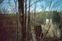 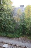  |