| Home | Open Account | Help | 390 users online |
|
Member Login
Discussion
Media SharingHostingLibrarySite Info |
Eastern Railroad Discussion > Atlantic County (NJ) Bikeway (ex-PRSL)Date: 09/16/17 18:08 Atlantic County (NJ) Bikeway (ex-PRSL) Author: OCtrainguy To expand the number of rail-trails I’ve ridden on, my daughter and I recently rode on a trail in Atlantic County. The Atlantic County Bikeway occupies a 7.5-mile abandoned rail line of the West Jersey and Atlantic Railroad, which became part of the Pennsylvania-Reading Seashore Lines. The Atlantic County Park System maintains the 7.5 mile trail running between Harbor Square (formerly Shore Mall) in Egg Harbor Township and the Atlantic County Institute of Technology in Hamilton Township. The eastern end of the trail is just west of the Garden State Parkway.
Originally, this line went from Camden, NJ to Atlantic City, NJ. From what I have been advised, this was the PRSL Newfield branch as in Newfield, the line split, with one branch going to Millville and the other going to Atlantic City. My daughter and I did five miles out and the five back. I was hoping to ride the full length, but will need to save that for another trip. The trail was very level, with several road crossings and some of those tied into traffic lights. Onto the photos. 1. Welcome sign and the entrance to the trail 2. Typical view of the trail as we head west 3. The width of the ROW looked to have supported two tracks here, and there were several areas where you could still see ties in the ground which confirmed what I thought A few more to follow... 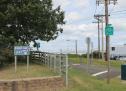 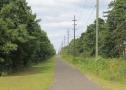 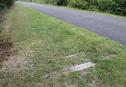 Date: 09/16/17 18:22 Re: Atlantic County (NJ) Bikeway (ex-PRSL) Author: OCtrainguy Continuing the photos.
4. This area had a small concrete wall on both side of the ROW. From what I have been told, this is the site of the West Jersey and Seashore Railroad's Cardiff station. This is roughly where West Jersey Avenue and Atlantic County Route 684 meet. 5. The eastern end of the trail, looking east toward the Garden State Parkway 6. After our ride, we saw a nearby Wawa where we used the facilities and refilled our drinks. While exiting on the east side, I noticed a grade crossing on the opposite side. So of course I had to investigate. This is Fire Road (County Route 651 according to Google). The looks did not look very overgrown at all and there were crossbucks with flashers. The Southern Railroad of New Jersey still uses this line from time to time. They use the current NJT Atlantic City line to access trackage in Pleasantville and this area. Since I was driving, my daughter used my camera to get this photo. I couldn't really stop due to having traffic behind me (of course!). This view is looking west, toward the Garden State Parkway. Not sure what the structure is at the right of the photo, but it looks relatively new. Hope you enjoy the photos. Like previously said, I plan to return to ride the whole trail and get some more photos of this grade crossing. Any additional history is always welcome. 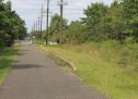 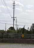 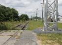 Date: 09/16/17 20:53 Re: Atlantic County (NJ) Bikeway (ex-PRSL) Author: Clarence I think that's a concrete batching plant, where they mix up the concrete that get delivered to the job site.
Clarence Date: 09/17/17 05:11 Re: Atlantic County (NJ) Bikeway (ex-PRSL) Author: PRR_4859 That line was electrified the entire way from Camden to Atlantic City until 1931. The branch to Millville was also electrified. The Western 4 miles were electrified via trolley wire due to all of the crossings in Gloucester City, then the rest was powered via third rail. The station in Atlantic City was on Tennessee Avenue. The line itself maintained freight service, but I think was abandoned in the 1960s, except for the short section around Pleasantville. When passenger service ended on the Newfield to Atlantic City section, the PRSL renamed the station at Absecon to Absecon - Pleasantville. When electrified trains ran, they were supposedly low seniority jobs due to the light weight on the drivers.
The Southern Railroad of New Jersey currently comes off NJ Transit's Atlantic City Line at "Griff" interlocking and comes South across the Atlantic City Expressway towards Pleasantville with stone trains (and at one time Somers Point to a lumber company). There was even a branch many years ago that came South off the Atlantic City Line to Mays Landing (in PRSL days), but that was ripped up many years ago. Edited 5 time(s). Last edit at 09/17/17 05:17 by PRR_4859. Date: 09/17/17 09:19 Re: Atlantic County (NJ) Bikeway (ex-PRSL) Author: choodude PRR_4859 Wrote:
------------------------------------------------------- > There was even a branch many > years ago that came South off the Atlantic City > Line to Mays Landing (in PRSL days), but that was > ripped up many years ago. Mays Landing is the county seat complete with a court house. My father in law told stories of how back in the day the "justice" would get a lot swifter as afternoon train time approached, especially from the Atlantic City lawyers. Brian Date: 09/20/17 05:04 Re: Atlantic County (NJ) Bikeway (ex-PRSL) Author: PlyWoody The first tracks built in Mays Landing was a portage tram which might have had wooden rails from Weymouth Iron Works down to a wharf in Mays Landing Court House. That was in the 1840s before the Camden & Atlantic Rail Road built to Atlantic City after 1852. Some of the same people were involved so some of the engineering on the tram aided the design of the C&A. Next came a branch railroad called the Egg Harbor & Mays Landing RR that went to the same wharf in Mays Landing. When the West Jersey & Atlantic first built a single track from Newfield to Atlantic City in 1880, they built straight over that wharf and filled in the riverfront property as the EH&ML RR had been abandoned. In 1906 the WJ&S completely rebuilt the WJ&A to a double track 3rd rail electric line. During the WW-1 the Bethlehem Loading Co. (Part of Bethlehem Steel) built a very large Cantonment down the west side of the Egg Harbor River with standard gauge track to power plant and connected to an extensive 2' narrow gauge railway that looped further down river nearly to the Tuckahoe River. This land is now owned by Atlantic County and is called Bellcoville after Bethlehem Loading Co. The Cantonment loaded and stored shells, and was served by a WJ&S class H engine daily moving shells in and out. The old NG track road bed are now hiking trails in the preserve protecting billions of mosquitoes and a few deer and snakes.
Edited 1 time(s). Last edit at 09/20/17 16:43 by PlyWoody. |