| Home | Open Account | Help | 373 users online |
|
Member Login
Discussion
Media SharingHostingLibrarySite Info |
Eastern Railroad Discussion > Northeast Corridor Photo HelpDate: 12/09/18 16:18 Northeast Corridor Photo Help Author: NB1001 I acquired a slide taken by the late Walter Shopp in 1975. It shows a train on the Northeast Corridor. I believe that the bridge that the train has just crossed is the Hackensack Draw in Secaucus. I am stumped as to where the photographer was standing when he took the shot. It is clearly taken from an elevated position and the shot is not a telephoto shot. Any ideas?
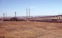 Date: 12/09/18 16:46 Re: Northeast Corridor Photo Help Author: CPR_4000 Pretty sure that's the infamous Portal draw. He might have scaled a floodlight tower at the nearby Erie Lackawanna yard or maybe a power pole? The former Lackawanna main line was still in place at that time -- maybe he was on a signal bridge.
Edited 1 time(s). Last edit at 12/09/18 16:48 by CPR_4000. Date: 12/09/18 17:19 Re: Northeast Corridor Photo Help Author: rbenko I've never seen this angle before - very cool!! Thanks for posting.
Definitely Portal bridge with an eastbound headed towards Penn Station. I agree that the photographer probably scaled some sort of light tower or high tension pole. However, it was probably located on the ex-Erie's Greenwood lake branch, which up until the early 2000's was NJT's Boonton branch. Due to the Montclair connection which connected the former end of the DL&W's Monclair branch with the Erie's Greenwood Lake branch, the portion of the line that went under the corridor just to the right of this photo is now abandoned. Date: 12/09/18 17:24 Re: Northeast Corridor Photo Help Author: boejoe Is that the New Jersey Turnpike in the background (elevated, climbing highway)?
Date: 12/09/18 18:54 Re: Northeast Corridor Photo Help Author: Mikedc3 Look here: https://goo.gl/maps/vBUyWrAHoSU2
If you pan to the right, there's a hill there. The pic may have been taken from that hill. Mike DeCarlo Hopatcong, NJ My Photobucket page Date: 12/10/18 05:40 Re: Northeast Corridor Photo Help Author: choodude boejoe Wrote:
------------------------------------------------------- > Is that the New Jersey Turnpike in the background (elevated, climbing highway)? Yup. In that part of New Jersey, the Turnpike is split into separate roadways. That is the eastern roadway in the picture. The western roadway is roughly a mile farther away in this area. Brian Date: 12/10/18 06:08 Re: Northeast Corridor Photo Help Author: RichM Snake Hill... once the site of NJ Trap Rock (I think)
Date: 12/10/18 06:52 Re: Northeast Corridor Photo Help Author: Lackawanna484 It's an interesting picture, that's for sure.
I don't know if the picture could have been taken from the Greenwood Lake line right of way area. That angle would be sharper, and a little farther back. The fields in the foreground slope up toward the photographer, but he's clearly on some point of elevation. ETA agree that the little hill and maybe a step ladder is the site Edited 1 time(s). Last edit at 12/10/18 07:59 by Lackawanna484. Date: 12/10/18 06:58 Re: Northeast Corridor Photo Help Author: CPR_4000 RichM Wrote:
------------------------------------------------------- > Snake Hill... once the site of NJ Trap Rock Snake Hill was on the west side of the Turnpike, just to the right of this photo. Date: 12/10/18 07:46 Re: Northeast Corridor Photo Help Author: RichM Oops... sorry... thought I was looking east... got it, no tall buildings in the background.
Thanks for clarifying. Date: 12/10/18 08:07 Re: Northeast Corridor Photo Help Author: Tominde An early drone?
Date: 12/10/18 08:33 Re: Northeast Corridor Photo Help Author: choodude Mikedc3 Wrote:
------------------------------------------------------- > Look here: https://goo.gl/maps/vBUyWrAHoSU2 > > If you pan to the right, there's a hill there. The pic may have been taken from that hill. Is that "hill" where they dumped the wreckage from Penn Station New York? Brian Date: 12/10/18 10:26 Re: Portal Author: timz Apparently he was on the powerline tower
at 40.75379N 74.08037W https://goo.gl/maps/Uevi9MxGJXU2 It's the right direction. Maybe they were erecting the tower? (But, if we can believe the dates on historicaerials.com, the tower wasn't there in 1979.) Edited 1 time(s). Last edit at 12/10/18 11:00 by timz. Date: 12/10/18 11:08 Re: Portal Author: cjvrr Looking at Historic Aerials, there appears to have been an active garbage dump at that location in the 1970s. Could have been taken from the pile.
Date: 12/11/18 17:33 Re: Portal Author: stanhunter Looking at the current Google aerial, there's a park (possibly the old dump) directly to the east of Portal bridge (circled in green). It looks to be about the right height, and easily accessible. I highly doubt that he climbed a tower to get that shot - it's not high enough. My bet is he's along the trail east of the Portal Bridge, shooting west.
Stan Hunter Fair Oaks, CA 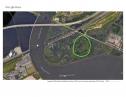 Date: 12/11/18 17:40 Re: Portal Author: timz You can't have a dump without a road for the trucks
bringing stuff to the dump. Such a road would still exist, to some extent, and would be visible on the aerial pics. Looks like there was an older power line along the Erie, and that must be where the guy was. Such a tower would be plenty high, if it existed. He probably wasn't even at the top. |