| Home | Open Account | Help | 307 users online |
|
Member Login
Discussion
Media SharingHostingLibrarySite Info |
Passenger Trains > Exploring the DC Streetcar routeDate: 02/16/19 14:08 Exploring the DC Streetcar route Author: casco17 In search of more new (to me) mileage, I rode the DC Streetcar on Sunday the 10th. It's still free; there were several riders along the route.
1. DC Streetcar (barely visible) on the H Street Bridge over Union Station tracks. 2. DC Streetcar interior; the cars were very clean. 3. End of track (for passengers) on Benning; the streetcar continues a little further on the tail track for a layover before reversing course Continued 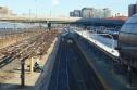 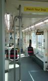 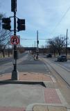 Date: 02/16/19 14:14 Re: Exploring the DC Streetcar route Author: casco17 4. This spur stub is near the eastern end of the route - future extension?
5. This is the spur track to the shop. The yellow highway sign in the median advises drivers not to follow the streetcar onto its private right of way. 6. A view of the 'training facility'/carbarn continued... 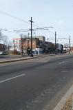 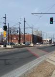 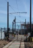 Date: 02/16/19 14:24 Re: Exploring the DC Streetcar route Author: casco17 7. On H Street, the streetcar shifts from a curbside lane to the center of the street on a flange-squealing S-curve. Note the siding with the bumping post - on an uphill grade. This is on the bridge over Union Station. Here's another stub spur - future expansion west?
8. Another view that shows the streetcar at its western terminal; Union Station passenger tracks are visible at right. The concrete structure to the left of the streetcar is the bus station (Greyhound and others); there is a walking corridor to Union Station. This area has been gentrified in the past couple years; new residences and businesses. IIRC the original plan was to have the streetcar traverse a longer route, but I have not followed the story all that closely. Edited 1 time(s). Last edit at 02/16/19 14:27 by casco17. 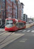  Date: 02/16/19 16:25 Re: Exploring the DC Streetcar route Author: Lackawanna484 The streetcar line has gentrified some of its route already. And there's new construction.
The line was originally mapped into neighborhoods south of the Anacostia River. Where many people need reliable public transportation. Posted from Android Date: 02/16/19 16:49 Re: Exploring the DC Streetcar route Author: Duna Nice photos, thanks for posting. I like that tiny stop sign in photo # 6.
So few people, could be a Twilight Zone episode. What day-of-week & time were the shots taken? Date: 02/16/19 17:26 Re: Exploring the DC Streetcar route Author: casco17 This was roughly 10:30-11:30am on Sunday 2/11. I intentionally left people out of some pics, as people don't always want their picture taken. I would say there were a dozen or so riders each way. It was a chilly day - breezy in the 30s.
Date: 02/16/19 17:47 Re: Exploring the DC Streetcar route Author: mundo Thanks for posting your photo's. Now I have a better understanding.
Date: 02/17/19 05:34 Re: Exploring the DC Streetcar route Author: tramfan Thanks for the photos. I have a five hour layover before boarding the WB Capitol in Aprila and hope to do some railfanning on the DC Streetcar.
Date: 02/17/19 14:52 Re: Exploring the DC Streetcar route Author: BRAtkinson I took my first ride on the line last August or so in the early Tuesday afternoon. The line was well patronized and perhaps 8-10 people on/off at each stop.
What amazed me was the incredible amount of new construction going on and recently completed. New high rise apartments going up and I checked a couple of their websites...$1500-1800/mo for a one bedroom apartment as I recall. There were a number of newer stores and shops that were busy as well. If I had a downtown Washington job with a good pay check, I'd certainly give consideration to those apartments and short commutes. Date: 02/18/19 08:33 Re: Exploring the DC Streetcar route Author: TAW casco17 Wrote:
------------------------------------------------------- > 7. On H Street, the streetcar shifts from a > curbside lane to the center of the street on a > flange-squealing S-curve. Note the siding with > the bumping post - on an uphill grade. This is on > the bridge over Union Station. Here's another stub > spur - future expansion west? That was/is planned, but beyond Union Station is the no overhead wire zone. They don't want to return to the conduit system of underground traction power supply. That presents a little bit of a challenge in a plan already loaded with challenges. TAW Date: 02/19/19 06:42 Re: Exploring the DC Streetcar route Author: choodude TAW Wrote:
------------------------------------------------------- > casco17 Wrote: > -------------------------------------------------- > ----- > > 7. On H Street, the streetcar shifts from a curbside lane to the center of the street on a flange-squealing S-curve. Note the siding with > > the bumping post - on an uphill grade. This is on the bridge over Union Station. Here's another stub spur - future expansion west? > > That was/is planned, but beyond Union Station is the no overhead wire zone. They don't want to return to the conduit system of underground > traction power supply. That presents a little bit of a challenge in a plan already loaded with challenges. > > TAW Perhaps the emerging technology that allows running battery powered equipment for the "open" distance then recharging under the catenary will mature enough to be viable. Brian Date: 02/19/19 07:28 Re: Exploring the DC Streetcar route Author: TAW choodude Wrote:
------------------------------------------------------- > Perhaps the emerging technology that allows > running battery powered equipment for the "open" > distance then recharging under the catenary will > mature enough to be viable. Can't say much more, but yup. TAW Date: 02/19/19 09:15 Re: Exploring the DC Streetcar route Author: justalurker66 How far does the "no overhead wire" zone extend?
|