| Home | Open Account | Help | 310 users online |
|
Member Login
Discussion
Media SharingHostingLibrarySite Info |
Passenger Trains > Elko Amtrak specificsDate: 06/19/21 10:25 Elko Amtrak specifics Author: JDLX Rather than try adding to yesterday's thread, I figured I would start a new one to explain some of the history and issues.
Prior to Project Lifesaver, which moved the tracks out of downtown Elko, the SP ran through what is now mostly parking lots between Railroad and Commercial streets a block south of Idaho Street, which was US 40 before the Interstate. The WP ran down the middle of Silver Street another block to the south. The WP depot lay at the corner of Silver and Third, directly across the street from the famed Star Hotel (blue dot on one of the attached images), while the SP depot lay a third of a mile away near 7th Street (red dot on the attached map). Elko always was a WP town, its yards and shops were located west of the downtown area. I want to say Amtrak used the old SP passenger depot in town before the line changes, but to be honest I'm not completely sure of that. As noted in yesterday's thread the Federal government instituted bidirectional operations on the SP and WP between Weso (just east of Winnemucca) and Alazon (just west of Wells) during the period of time it directly operated the railroads during the first World War, the two railroads initially pulled back to their own lines after the war but in retrospect realized the benefits of the arrangement and returned to the practice after a few years. Project Lifesaver moved the lines of the two railroads together next to the river two blocks south of Silver Street. The WP got an entirely new switching yard, shop, offices, and other facilities built east of town. It would be interesting to know now what the discussions were around how to handle Amtrak at that time. Placing the railroad lines up against the river significantly limited the options, as there was no room in the downtown area to build anything serving the eastbound trains on the WP side, and the city built a sound wall along pretty much the entire length of the tracks on the SP side. In retrospect the best option for easing rail service would have been a single depot of some sort on the SP with crossovers on either side, but for whatever reason what got built was a pair of passenger loading platforms and small passenger shelters located directly across the tracks from each other just east of the 12th Street bridge. The problem with this arrangement is that for various reasons there never has been any way provided for people getting on and off trains to get to the other platform, which is about thirty-five feet away. There is a fence between the tracks extending through the depot area, and tall fencing along both sides of the tracks. Access to the loading platforms are through gates unlocked by the conductor when the train arrives so that people can get on and off the loading platforms. If say you take a weekend train trip from here to Reno and inadvisably leave your vehicle in the parking lot next to the westbound depot, there is no safe or legal way to get across the tracks to get back to your vehicle when you step off that eastbound train. Your car may only be fifty or sixty feet from where you stand after the conductor ushers you through the gate; the only quasi-legal way to get to the westbound side is to walk west (uphill) along Sharp Access Road, no street lights or sidewalks and it's a gravel road surface, to the intersection with 12th Street. There is a pedestrian sidewalk across the 12th Street bridge, but it is along the west side of the travel lanes and separated from the vehicles by a crash barrier. You would either have to illegally cross 12th Street and then climb over the crash barrier to reach the sidewalk, or you would have to walk along the very narrow shoulder across the eastern side of the bridge with no protection from vehicles and no real distance from them, or way to escape should a vehicle leave the travel lane. Once over the 12th Street Bridge one has to make a left on River Street- no crosswalks across the street here either if you elected to not cross the street and vault over the crash barrier on the other side of the bridge- then go west for a block on River Street, walk the long block down to Water Street, then go back east along Water Street underneath the bridge so as to reach the westbound depot. All told it's about a mile walk, very little of it on sidewalks, and mostly without any street lighting or other illumination. And, as noted in the article, both trains pass through Elko at night unless the westbound Zephyr is running extraordinarilly late. Yes, there are no doubt many other options that could have been used to provide the access from one side of the tracks to the other at the depot area. There are a number of issues with each of them. 1. Pedestrial overpass. The railroad is pretty hemmed in by roads on both sides in the vicinity of the depot. Obviously any such structure would have to get high enough to not create any vertical clearance issues over the railroad. Anything built now would need to be ADA compliant, which puts some hard and fast limits on the grade of the walkway and requires periodic flat spots for wheelchair bound people to rest, and to break decent while going down. There isn't room on either side of tracks at this location to build curving ramps, which limits any such structures to long ramps running parallel to the tracks in either direction. And that's assuming UP would be willing to let such a structure be built within their right-of-way. Perhaps the best option would be some major modifications to the 12th Street Bridge to add a second pedestrial walkway along the east side of the structure. A pathway could be built along Sharp Access Road from the eastbound depot up to the bridge, provided it met the grading requirements, but there are a large number of issues with the north side of the bridge. Concievably a new ramp could be built from the bridge along the tracks between the railroad and Water Street, but a UP signal and some other railroad and utility infrastructure would have to be relocated. There's really no room to substantially increase the width of the 12th street footprint once it gets over Water Street without encroaching onto Western State Propane's yard, and then no real way to get back to Water Street outside of the circutitous route I already described once you get off the north side of the bridge. Otherwsie the only other real option is to run long ramps to the east of the depots and build a bridge that direction. 2. Pedestrian crossing. I seriously doubt UP would consent to such a crossing They already have many serious issues with people crossing their right-of-way in this area. Elko has a large homeless population that likes to spend time along the river, and there has been a constant battle between the railroad and the homeless who like to cross the tracks more or less directly underneath the 12th Street bridge. Even if safety gates or other crossing protection were to be installed, I cannot see how it would be in UP's interest to legitimize a pedestrian crossing in this area. 3. Underpass. Has a lot of the same grade and engineering issues as the overpass, The depot is also still next to the river and definitely in its flood plain, keeping the underpass dry would be a real challenge. 4. Installing crossovers at either end of the depot so that eastbound trains could use the westbound platform. Again, it would require UP's consent. Obviously we are talking serious money with any one of these engineering solutions. Perhaps the contract to haul passengers is the most cost effective solution to the problem, at least in the short term. One other factor to keep in mind, for a while now anybody holding a Greyhound bus ticket between Reno and Salt Lake gets put on the train between those two points, so it's not just Amtrak passengers that are affected by this situation. Jeff Moore Elko, NV 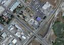  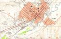 Date: 06/19/21 11:33 Re: Elko Amtrak specifics Author: Cupolau If you decide to haul passengers you will need a small van which will need to be handicap accessible and the driver will need be on call because the westbound Zephyr can be very late. If the city can find other uses for this van then it would be more cost effective. The story about moving the tracks away from where the parking lots are now located, I was told by some of the old timers it was to cut down on the number people getting hit while crossing from the Commercial to Stockmen's hotel and casino. Some that were very inebriated.
Date: 06/19/21 11:44 Re: Elko Amtrak specifics Author: joemvcnj Nothing is easy or cheap.
Perhaps the county got a rural FTA grant to purchase accessible vans for their seniors and handicap, so can spare one of them for the few minutes each day Amtrak, which is also the Greyhound service, is there. Since it is due when most are asleep, not a high demand time. South Bend comes to mind on a double track railroad with 2 separate platforms. How do they handle crossing the tracks ? Posted from Android Date: 06/19/21 11:46 Re: Elko Amtrak specifics Author: symph1 Thanks for such a clear explanation. It's great. Can you please tell us what year the map shows? Also, what year did they relocate the tracks?
Date: 06/19/21 11:52 Re: Elko Amtrak specifics Author: prr60 Just spit-balling: Establish pedestrian crossings at the station one at each end of the platform. Incoming trains would position such that the last car is clear of the crossing. If there are exiting passengers that need to cross the tracks, the Amtrak conductor would contact the UP dispatcher and obtain a temporary block on the other running track. If a train were approaching on the open track, Amtrak would hold until it passes. Having confirmed the block, the conductor would escort those passengers to the open crossing. Once those passengers exited the station, the conductor would release the block with UP, lock the station and leave. This is similar to what I assume occurs when Amtrak has to stop at a single-platform station and needs to use non-platform track requiring passengers to cross an active track (thinking video-favorite La Plata MO).
Date: 06/19/21 12:29 Re: Elko Amtrak specifics Author: JDLX The map is a snip of the 1957 Elko West USGS 1:24000 quad. And 1983 sticks in my mind as the date the line change opened.
This isn't the best photo, but this view is looking down that Sharp Access Road from near the connection with 12th Street during the major flooding Elko experienced back around 2017. The Amshack for eastbound trains is right about the middle of the photo. One potential issue with the idea of a controlled pedestrian crossing as suggested is that it's pretty common for eastbound trains to arrive in Elko in fleets, and quite often there is a freight sitting on the eastbound main through the Amtrak depot waiting for other trains ahead of it to clear so that it can get into the yard. Jeff Moore Elko, NV Edited 1 time(s). Last edit at 06/19/21 12:32 by JDLX. 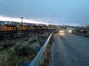 Date: 06/19/21 13:00 Re: Elko Amtrak specifics Author: mundo Thanks Jeff. You have explained the issue. I did what I could but years since I was in Elko.
Interessting on the Greyhond issue, I had not thought of that. Ed Date: 06/22/21 22:20 Re: Elko Amtrak specifics Author: HRWest Great piece Jeff...
Terrence Holdeman Wells, NV |