| Home | Open Account | Help | 229 users online |
|
Member Login
Discussion
Media SharingHostingLibrarySite Info |
Railfan Technology > OT - Google Earth IssuesDate: 02/02/24 09:29 OT - Google Earth Issues Author: train1275 I use google earth for measuring distances along tracks to mark distances to try and locate features on Val Maps or other sources. It gets me close enough to understand where something used to be, or what the distances are between several points.
Anyway, for 20 years it has worked fine. It worked fine last week. Now today it doesn't. From the screen shot attached, can anyone tell me what is going wrong ? I click on the ruler and as I bring the cursor to the starting point it puts multiple tags on the screen and as I measure it obliterates the screen with multiple distance tags until it obscures everything. I don't understand it and can't seem to figure out how to fix it so it works. Anyone have any ideas ? 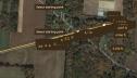 Date: 02/02/24 17:12 Re: OT - Google Earth Issues Author: NSDTK I just tried Google Earth Pro, no issues. Maybe check for a update ?
Date: 02/03/24 07:41 Re: OT - Google Earth Issues Author: train1275 NSDTK Wrote:
------------------------------------------------------- > I just tried Google Earth Pro, no issues. Maybe > check for a update ? Thanks, that seemed to do the trick. It worked ok for me last week, but then this week it didn't. All good now ! Date: 02/05/24 13:42 Re: OT - Google Earth Issues Author: radar Google Earth Pro seems to need a lot of computer resources, or it acts up. I always try to reboot before using it, and and avoid running a bunch of other programs at the same time.
Date: 02/07/24 12:47 Re: OT - Google Earth Issues Author: busdriver What is Val Maps. I like tracing current and old ROWs in AZ on Google Earth, and I'm wondering if this might be useful.
Thanks. Bryce Date: 02/07/24 14:15 Re: OT - Google Earth Issues Author: train1275 Valuation Maps started in the WWI era and were used to record railroad properties and structures as part of the valuation for the USRA.
They show how the rail lines were laid out from a property map approach and generally record the parcels and deeds and easements, etc. acquired for each section of track. There can be original circa 1916 - 1918 versions and also to be found are updated versions made in later years to record property sales, acquisitions, additions of buildings, removal of buildings and changes in track. Attachment 1 is a map section, in this case DL&W RR at South Columbia, NY Attachment 2 is the property record of a different map Google on the internet and many of these can be found in specific railroad historical societies of your liking or the National Archives in College Park, MD One of the things you can do is take the chaining stations on the maps and convert them to feet to measure off to some present existing location, such as where a turnout was located or a station building or tower. Edited 2 time(s). Last edit at 02/07/24 14:55 by train1275. 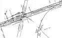 Date: 02/07/24 14:37 Re: OT - Google Earth Issues Author: busdriver Thanks for the details!
Bryce |