| Home | Open Account | Help | 257 users online |
|
Member Login
Discussion
Media SharingHostingLibrarySite Info |
Western Railroad Discussion > Aerial Images: Eugene, OR to Cascade SummitDate: 09/15/08 17:56 Aerial Images: Eugene, OR to Cascade Summit Author: cinder OK...Here goes. The following aerials were taken from a Cessna 172 between 10:30am and noon on Tuesday, September 9. The weather was perfect with little wind. There are 18 pictures so give me time to load up.
1. A southbound manifest with two dp units on the rear (in picture) enters the north end of the yard in Eugene around 10:30am. We'll see this train again. Also note the 10 UP units tied together. 2. The roundhouse/turntable area in Eugene. 3. Industrial switching taking place south of downtown Eugene. The engines aren't UP. What is the railroad? 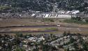 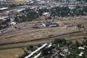  Date: 09/15/08 18:05 Re: Aerial Images: Eugene, OR to Cascade Summit Author: cinder 4. Oakridge, OR, 41 highway mi. south of Eugene. A string of ballast cars is visible as is a three-unit work train set on the wye.
5. A ground view of work train units later in the day. These same units were photographed two days later near the summit. 6. The horseshoe curve just south of Oakridge (visible at the top). 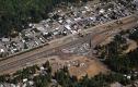 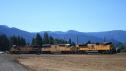 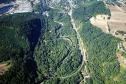 Date: 09/15/08 18:14 Re: Aerial Images: Eugene, OR to Cascade Summit Author: cinder 7. The rear dp units on the manifest shot earlier in Eugene wait on a siding five miles south of Oakridge around 3pm.
8. Amtrak #14 comes off the mountain at Heather at 3:15pm, after being held near Cascade summit. 9. The first of a few shots of the Oakridge/Fraser slide area. 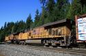 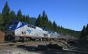 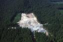 Date: 09/15/08 18:21 Re: Aerial Images: Eugene, OR to Cascade Summit Author: cinder 10. Slide area
11. Slide area 12. The lower portion of the slide is on the left and Highway 58 is in the center of the picture adjacent to Salt Creek. A lower section of the railroad is seen to the right of the highway. 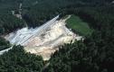 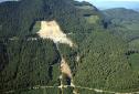 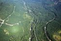 Date: 09/15/08 18:25 Re: Aerial Images: Eugene, OR to Cascade Summit Author: cinder 13. The upper loop area. Note the wye.
14. A closer look at the wye. 15. UP's horseshoe crossing of Rt. 58 at the base of the loops. 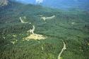 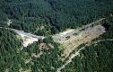 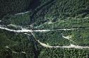 Date: 09/15/08 18:38 Re: Aerial Images: Eugene, OR to Cascade Summit Author: cinder 16. A snowshed hung on the mountain above the loops.
17. The south portal of the last tunnel before Cascade summit. Odell Lake is barely visible to the right. 18. A ground image of a northbound ballast train approaching the same south portal two days later. The three-unit set was sitting on the wye in Oakridge two days before. The southbound manifest shot at 10:30am in Eugene and 3pm south of Oakridge arrived in Chemult around 10pm.......150 miles in 12 hours. If you would like to purchase these images and a few more in high resolution format on a CD (and I'll throw in two aerials of the Tehachapi Loop), send me $10, and I'll send you the CD. The $10 includes postage. Hey, I have to pay for the flight. 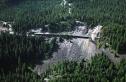 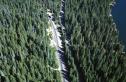 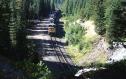 Date: 09/15/08 18:45 Re: Aerial Images: Eugene, OR to Cascade Summit Author: roustabout cinder Wrote:
------------------------------------------------------- > > 3. Industrial switching taking place south of > downtown Eugene. The engines aren't UP. What is > the railroad? The picture is of the Weyerhaeuser Local and it's switching Borden Chemical in Springfield. The bulk of their train is in Glenwood. Power is a pair of HLCX leasers (maroon color scheme). Date: 09/15/08 19:44 Re: Aerial Images: Eugene, OR to Cascade Summit Author: cinder Thanks for all the info jb!
Date: 09/15/08 19:49 Re: Aerial Images: Eugene, OR to Cascade Summit Author: Yarddogh Great tour of that area. Surprised to see the extent of the slide seen in summer light.
Nice crisp photos. 'Dogh Date: 09/15/08 20:18 Re: Aerial Images: Eugene, OR to Cascade Summit Author: nycman Cinder, I always enjoy your aerials, and those are the best photos I have seen of the slide area and really show what happened there.
Date: 09/15/08 20:56 Re: Aerial Images: Eugene, OR to Cascade Summit Author: Yardmaster The 3 units you saw at Fields are not helper units, but rather the power for the work train. There are two sets of 3.
Date: 09/15/08 22:09 Re: Aerial Images: Eugene, OR to Cascade Summit Author: syscom3 I remember the slide area when I took the Amtrak from Portland.
Lots of heavy eqmt on the service roads. Date: 09/15/08 23:25 Re: Aerial Images: Eugene, OR to Cascade Summit Author: TCnR Awesome. Looks different when you can see above the trees to the next level of track. Thanks for the comments about Fields, I remember it with bunkcars and other odd looking old cars all over the place (of course no photos, I'll come back later and get 'em). Once again looks a lot different from the air.
Date: 09/16/08 11:41 Re: Aerial Images: Eugene, OR to Cascade Summit Author: fredkharrison Your aerials of the switchback on the Cascade Line show the fragile volcanic ash composition of the steep slope real well. They also show extensive clearcutting activity above, below and between the upper and lower tracks.
One would wonder if the UPRR is very concerned about the liklihood of a repeat performance of the Frasier Slide during the winter storms and spring thaws in the years ahead and if the UPRR is seriously considering constructing water bleed-offs along the ROW to reduce overburden from saturation due to a high precipitation event or heavy snowpack. Fred Harrison Central Point, OR CORPpower/JSS/EORS Date: 09/17/08 09:45 Re: Aerial Images: Eugene, OR to Cascade Summit Author: Yarddogh Excellent review and analysis of information relating to 'the slide'. Thanks for adding that.
( Not going to be tilting my pancakes when I fork through them ! ) 'Dogh |