| Home | Open Account | Help | 388 users online |
|
Member Login
Discussion
Media SharingHostingLibrarySite Info |
Western Railroad Discussion > Bakersfield - Early 2013Date: 12/11/12 11:06 Bakersfield - Early 2013 Author: v1perfan Hi all,
So it looks like I will be heading out to Bakersfield, CA for a course early next year. However, I plan on leaving a few days early specifically to do some rail fanning. So with that said, I already have a few places in mind (I have not taken into consideration Bakersfield proper yet - all of my pictures so far will be heading towards the Loop): 1) The bridge on Bena Rd. 2) Various locales in Caliente (tunnel on Caliente-Bodfish Rd, etc.) 3) Bealville Tunnel 4) Train bridge on Woodford-Tehachapi Road) 5) The Loop 6) A few locales on Howermancel Road I'm staying at the Extended Americas in Bakersfield (I have asked for a room on the top floor facing the yard ha ha). Other than the loop, has anyone been to any of the places I mentioned? If so, can I safely take pictures from any of those locations without getting into any kind of trouble (I have seen the name "Rusty" recurring in several threads). With regards to the loop, what is and is not considered to be "railroad property"? In 2008 when I was there I was able to take a picture from one of the hills that faces the loop (looking at Google maps, there is a small dirt road that leads up to some type of roughed-in parking lot with a path leading to the top of the hill - coordinates 35.197865,-118.532455). Is that still a viable place to get pictures and video, or am I looking for trouble if I go there? Also, I have an older scanner (Radio Shack, not sure of the model but I can get if it matters). Will it still work due to the changes/changing frequencies? If so, what frequencies should I set it to scan? Since I will be in Bakersfield I might take some time out to do some rail fanning there, so does anyone have any suggestions? Are there any other places other than what I mentioned where I should go? Sorry for all of the questions - I thought getting everything into one message would be more efficient than a series of messages. :P Thanks in advance! Brian. Date: 12/11/12 11:40 Re: Bakersfield - Early 2013 Author: SCUfoamer To begin. You have selected the popular and most easily accessible spots on Tehachapi. The look these days is rather difficult to rail fan from with in...The newest and LEGALIST spot would be to drive up to the monument on the Southwest side of the loop up high. From that point you can make a left turn onto a dirt patch and walk in. This is a great spot because you can see Eastbounds approaching the loop and Walong and you can see Westbounds approaching the loop from Cable (might have switched up these two points of Interest). You can also see the ENTIRE loop from that point which is great.
As far as bakersfield is concerned there isn't a lot of superb photo spots in the City. If you take Truxton Ave all of the way through Bakersfield that road parallels the BNSF main through the city and turns into Edison HWY and that will take you all of the way to BENA. At about F street and Truxton is the BNSF office. This would be the ideal place to begin a chase because it is where crew changes take place and most trains will stop briefly before heading towards the hill. At the end of Edison HWY is a place called Sand Cut. This is a great spot if you make a left turn right before the cut onto a dirt road (my nissan altima made it up so don't worry). That dirt road goes to the top of the cut. It allows you to look down the main towards Bakersfield and down the great S curve to BENA frequencies: UP Bakersfield to Mojave- 160.320 BNSF Bakersfield Sub- 161.370, 160.935, 161.101 (Bakersfield switching) Any more info you'd like please PM me. I will be down there this month and early January as well, I make the trip from here in San Jose quite often Date: 12/11/12 11:50 Re: Bakersfield - Early 2013 Author: up833 Can you still park under the tree at Bealville...by the historic marker?
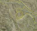
Roger B Date: 12/11/12 12:19 Re: Bakersfield - Early 2013 Author: loopy7764 I don't know if this would help. These are property boundaries defined by Kern County's GIS, the photo underlay isn't perfect but you get the idea.
 Date: 12/11/12 12:20 Re: Bakersfield - Early 2013 Author: stevelv up833 Wrote:
------------------------------------------------------- > Can you still park under the tree at > Bealville...by the historic marker? > Roger Bealville and associated trees are still accessible but if that Rusty guy comes around you might encounter a confrontation. I have never had the pleasure of meeting said individual but I always try not to be on UP property and when I am close to the ROW it's in places where there is no discernible line between UP and public (or) ranch property. Date: 12/11/12 12:37 Re: Bakersfield - Early 2013 Author: sjvflash I was chased away from there before but I park there anyway just not for a long time. Out of State plates might help.
Date: 12/11/12 16:24 Re: Bakersfield - Early 2013 Author: v1perfan SCUfoamer Wrote:
------------------------------------------------------- > > frequencies: > UP Bakersfield to Mojave- 160.320 > BNSF Bakersfield Sub- 161.370, 160.935, 161.101 > (Bakersfield switching) > > Thanks for the info - So I checked my scanner and it is a Radioshack Pro-29. Will that still work on the RR frequencies? Thanks! Brian. Date: 12/11/12 17:12 Re: Bakersfield - Early 2013 Author: rehunn The other consideration is what you define as early. The Valley can be socked in for a month
straight in February in low fog, some of which will hit close to the loop. Also the weather can be snowy making the roads a bit tricky. March usually is past most of that though some rain might happen, April starts to get much better. Date: 12/11/12 19:22 Re: Bakersfield - Early 2013 Author: v1perfan My time frame is the sometime in the first three weeks of January, so hopefully the weather will cooperate.
Date: 12/12/12 11:40 Re: Bakersfield - Early 2013 Author: AlcoRSD15 Bealville is accessible, but there are No Trespassing signs on the railroad west (North) side of the grade crossing. As for the Loop, I hear the dirt road from the paved Keene road to the tracks is now gated. I think Woodford is still accessible.
-- Eric Blasko Date: 12/16/12 10:41 Re: Bakersfield - Early 2013 Author: tronarail Yes, Sand Cut is a great place to watch the parade of trains heading towards the "Loop" or heading into Bakersfield. In view of the fact that you're planning a January 2013 trip, you should not encounter any dangerous critters. But 15 years ago in June (I think, and I still remember to this day) I had parked my Oldsmobile at the bottom of the dirt road (not really sure if I could make it to the top). Anyway, my little dog and I began walking up the road towards the top when the unmistakable buzz of a rattlesnake sounded from a nearby shrub no more than 2 feet from me. I froze in place and very slowly reversed my travel - however my little dog was not quite so careful and proceeded to walk into the bush with the snake issuing a couple of strikes. Very expensive anti-venom for my dog, and a very wise lesson for me. Be careful when walking through the brush on rail-fanning trips.
|