| Home | Open Account | Help | 366 users online |
|
Member Login
Discussion
Media SharingHostingLibrarySite Info |
Western Railroad Discussion > Extreme Flooding and a Tornado RiskDate: 05/24/15 07:30 Extreme Flooding and a Tornado Risk Author: kansas1 I know there are some people who get upset when I post weather information but I believe it is warranted in this case. There is a tornado risk later today from St. Louis to Shreveport and record flooding is affecting the railroads in Kansas, Oklahoma and Texas. More here: http://www.mikesmithenterprisesblog.com/2015/05/flood-and-tornado-update.html
We have been working with the railroads all week to mitigate the effects of the forecast flooding but there is only so much that can be done in a situation like this. In the Austin region, the Blanco River is 8' over the previous record and still rising. If you live in the the affected areas (tornado or flood), I urge you to keep up on the latest weather information. And, if you decide to try to take photos of trains in these conditions, please use extreme caution. 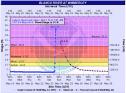 Date: 05/24/15 08:24 Re: Extreme Flooding and a Tornado Risk Author: sptno I live in South Austin and was watching the local this morning (Sunday). There is major flooding in San Marcos and from what they were saying only the northbound lanes of IH 35 in the San Marcos/Kyle area was open. Hopefully they can get the southbound lanes open later on today.
That area of Texas has to deal with the Blanco river which saw historic flooding as well as the San Marcos river. UP crosses both rivers, but having seen the UP crossing of the Blanco west of HI35, I don't think that the flooding on the Blanco impacted UP's operations on the Austin sub. Having visited the San Marcos area, I think that the flood in San Marco area has impacted. That could not be said for the Lockhart sub which probably is very near the Blanco river. More rain is coming on Monday. Hope that everyone has a safe Memorial Day. Date: 05/24/15 08:44 Re: Extreme Flooding and a Tornado Risk Author: PALuvR Here's a shot of the UP bridge over the Blanco River.
Mike 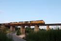 Date: 05/24/15 09:10 Re: Extreme Flooding and a Tornado Risk Author: CPR-489 Add in North Texas, North East Texas Southwest Arkansas and Northwest Louisana as well the Red River is already flooding in some area and is going higher. Lake Texoma damn is running over spillway by 3/4 inch with due to rise higher. With the area to get 5-7 inchs of more rain and us to get 3-6 inch here Texarkana area as well.
Here's cell photne shot of the Cotton Belt bridge at Garland City , AR by good friend of mine Willam Cornett. 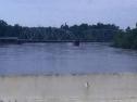 Date: 05/24/15 09:58 Re: Extreme Flooding and a Tornado Risk Author: PALuvR My shot of the Blanco River bridge was August, 2014. It's barely a trickle during the summer.
Mike Date: 05/24/15 11:22 Re: Extreme Flooding and a Tornado Risk Author: zchcsse How's the BNSF Transcon holding up?
-Tom Date: 05/24/15 12:45 Re: Extreme Flooding and a Tornado Risk Author: kansas1 Tom,
It appears the transcon is doing OK. Heavy rain fell but the worst was just to the south and parallel of the line. Mike Date: 05/24/15 16:35 Re: Extreme Flooding and a Tornado Risk Author: gman1 has all this finally brought Lake Travis up, I know at one point it was 30 feet below normal
Date: 05/24/15 16:59 Re: Extreme Flooding and a Tornado Risk Author: sptno Lake Travis is up some, near 48% capacity the last that I heard. Unfortunatley, we have not gotten the rains that we need in the Lake Buchanan and Lake Travis water sheds. More rain is coming so maybe we can get the lakes more rain.
Every drop helps. Pat South Austin, TX |