| Home | Open Account | Help | 372 users online |
|
Member Login
Discussion
Media SharingHostingLibrarySite Info |
Western Railroad Discussion > FluggenTour GorgeDate: 03/21/20 19:26 FluggenTour Gorge Author: BoilingMan Okay. I'm going to try out and idea... there are a lot of places on Donner Pass that are very familial to the outside world, thanks to Stein, Dorn and many others, but in a sense lack context. So I figured I'll give those of you that have never visited The Hill a look at the Lay-Of-The-Land. An aerial tour of sorts.
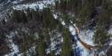
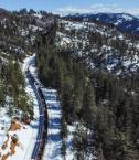
I'll start with my own back yard: Gorge. (AKA Rocky Point, Rawhide, Casa Loma, American, and Whatever- but Gorge would be the most historically accurate) Photo 1. A map of the neighborhood. Points to notice- I've marked the real location of American. American is famous as the spot where trains stopped so passengers could have a look-see over the edge.. but here's the thing- they were looking into the canyon of the North Fork of the North Fork of the American River. Why here? This canyon is only about half as deep as the North Fork proper- barely 2mi further West! My best guess is it had something to do with grade, or signals, or some other operational reason. The impressive narrows in the background is Giants Gap. To the left of The Gap is Iowa Hill and the right side is Moody Ridge. Photo 2. Looking RR West were the track rather suddenly meets the river canyon and it's 2000ft-ish drop. Photo 3. Turning 180 and looking RR East. The trip along the rim is brief, and the line turns to the North Fork of the North Fork drainage. Photo 4. Looking RR West again over Rawhide Crossing. The Grade crossing isn't plowed in the winter, so it's not obvious here, but it's under the second unit. The Rawhide Road goes down into the canyon to a gold mine. Anyway, it's a nice photo location for head end shots. Photo 5. Turning 180 again and looking RR East. American is around the last corner where the RR disappears in the distance. So was that worth the effort? If this seems like something that's interesting and informative I'll try a few other familiar spots or even take requests... SR 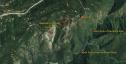 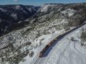 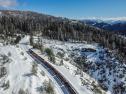 Date: 03/21/20 19:27 Re: FluggenTour Gorge Author: BoilingMan .
  Date: 03/21/20 19:52 Re: FluggenTour Gorge Author: FiveChime You forgot to show "Bush" which is east of Rawhide but west of American.
Regards, Jim Evans You must be a registered subscriber to watch videos. Join Today! Date: 03/21/20 20:27 Re: FluggenTour Gorge Author: BoilingMan That thing needs a caboose!
SR Date: 03/21/20 21:10 Re: FluggenTour Gorge Author: Steamman Nice pictures and video - both of you. Thanks.
Date: 03/21/20 22:06 Re: FluggenTour Gorge Author: coach Thank you for the map / photo--I always thought "Gorge" was "American." Now I need to go explore some more...
I met a Ranger at the Coloma State Park who has explored many old gold digging sites, and I bet he's been to this one down that crooked road to the river. There's still lots of gold left down there, if you can get it out. The history of this spot in the Sierra's is so amazing and "rich" that it keeps me endlessly reading.... Date: 03/21/20 23:03 Re: FluggenTour Gorge Author: BoilingMan Local advice advises not to go down to the Rawhide Mine. The old guy that lives at the site is said to be quite unpleasant or trigger happy- perhaps both!
Updated rumors say he’s dead. I suppose that would make him even MORE unpleasant! (But maybe less trigger happy?). Anyway, I’m pretty sure I’VE never gone down there! SR Date: 03/21/20 23:18 Re: FluggenTour Gorge Author: Odyssey Thanks SR for sharing the perspective historically,
geographically, and visually ... it does really add to your photography knowing the background "layout" ... appreciated! Odyssey Evergreen, CO Date: 03/22/20 04:35 Re: FluggenTour Gorge Author: KMiddlebrook Where is Cape Horn on your map?
http://cprr.org/Museum/Cape_Horn.html The following passage from page 6 of the above document.... "The view from the Cape Horn vista across Green Valley and down to the American River was a spectacular one and the Central Pacific gave it a lot of publicity by stopping passenger trains along the steep mountainside. This allowed the travelers to take in the magnificent views and brought the location into national prominence. Even though it was not the most spectacular view along the road, it was one of the few not enclosed within the miles of wooden snowsheds constructed over the summit which obstructed the view of the beauty of the Sierra crossing from the passengers. The fact that the roadbed had been blasted from this rocky outcropping made it that much more spectacular to think about and the CP Publicity men did their work well. Cape Horn soon became one of the places on the Central Pacific to see and the Tourist Guides of the day began telling their stories about the exciting and dangerous construction along this steep bluff." Edited 2 time(s). Last edit at 03/22/20 06:36 by KMiddlebrook. Date: 03/22/20 07:41 Re: FluggenTour Gorge Author: Evan_Werkema KMiddlebrook Wrote:
> Where is Cape Horn on your map? Several miles off the map to the left, just east of Colfax: https://goo.gl/maps/v8syJSSmGNVr8rTt6 Date: 03/22/20 08:05 Re: FluggenTour Gorge Author: WAF BoilingMan Wrote:
------------------------------------------------------- > Local advice advises not to go down to the Rawhide > Mine. The old guy that lives at the site is said > to be quite unpleasant or trigger happy- perhaps > both! > Updated rumors say he’s dead. I suppose that > would make him even MORE unpleasant! (But maybe > less trigger happy?). > Anyway, I’m pretty sure I’VE never gone down > there! > SR Send your drone down there to check it out. If you see life, get it out of there Date: 03/22/20 09:18 Re: FluggenTour Gorge Author: BoilingMan KMiddlebrook Wrote:
------------------------------------------------------- > Where is Cape Horn on your map? > > http://cprr.org/Museum/Cape_Horn.html > > The following passage from page 6 of the above > document.... > > "The view from the Cape Horn vista across Green > Valley and down to the American River was a > spectacular one and the Central Pacific gave it a > lot of publicity by stopping passenger trains > along the steep mountainside. This allowed the > travelers to take in the magnificent views and > brought the location into national prominence. > Even though it was not the most spectacular view > along the road, it was one of the few not enclosed > within the miles of wooden snowsheds constructed > over the summit which obstructed the view of the > beauty of the Sierra crossing from the passengers. > The fact that the roadbed had been blasted from > this rocky outcropping made it that much more > spectacular to think about and the CP Publicity > men did their work well. Cape Horn soon became one > of the places on the Central Pacific to see and > the Tourist Guides of the day began telling their > stories about the exciting and dangerous > construction along this steep bluff." Good lord! What a "Fact Salad" of almost correct info!! Straightening things out: Trains stopped at American for viewing- there was a platform built for the purpose. (long gone now, probably erased during double tracking) The article mentions the view not being the best. (as I'd noted too) This would be a fair description for American, but not Gorge or Cape Horn- they're both quite impressive! Snow sheds never went much below Blue Canon, so none of these places were ever hidden from views. But American would probably be the first place WB's had a panoramic view after the long sheds. Green Valley is below Gorge and can probably not be seen from American and definitely not from Cape Horn. Hope that helps... SR 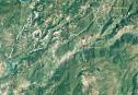 Date: 03/23/20 13:13 Re: FluggenTour Gorge Author: gaspeamtrak That video was amazing!!! :):):)
I thought for sure there would be "helpers" on there for sure!? Thank you for sharing!!! :):):) Date: 03/23/20 19:06 Re: FluggenTour Gorge Author: GN_X838 Great Video. I noticed that FRED wase't
Swede Albony,Or. Date: 03/23/20 19:31 Re: FluggenTour Gorge Author: coach I think I see the old "balloon" track above Blue Canyon in your second photo map!
Date: 03/23/20 19:38 Re: FluggenTour Gorge Author: BoilingMan Yes, that’s the Balloon Track but it’s still very much in service- saw plenty of action last week!
SR |