| Home | Open Account | Help | 324 users online |
|
Member Login
Discussion
Media SharingHostingLibrarySite Info |
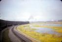
Steam & Excursion > ID help needed. Is this SP steam? Where?Date: 02/24/21 13:58 ID help needed. Is this SP steam? Where? Author: Conch I recently obtainded this slide up and am trying to get some information on it. No date but probably from between 1946 and 1949. I realize it's had to make out but maybe the surroundings will ring a bell for someone. Can't read any lettering on the cars, but it appears to be a pacific up front. Has large numbers (which I can't make out) like the SP did on the cab. Style B semaphores like the SP used just ahead of the train. Perhaps a sea level view in California? Seems to be a mountain in the distance on the right. Any help or comments appreciated.
Chuck 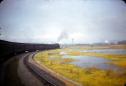 Date: 02/24/21 14:14 Re: ID help needed. Is this SP steam? Where? Author: wabash2800 It looks to have a Southern Pacific whaleback tender... and there are lower quadrant semaphores that were typical Southern Pacific. Could the location be Oakland, CA?
Victor A. Baird http://www.erstwhilepublications.com Edited 1 time(s). Last edit at 02/24/21 14:16 by wabash2800. Date: 02/24/21 14:26 Re: ID help needed. Is this SP steam? Where? Author: Conch Thanks for your input. I've attached a lighter view that might help. Tender looks like a Vanderbuilt.
 Date: 02/24/21 14:34 Re: ID help needed. Is this SP steam? Where? Author: wabash2800 I think you are correct. I saw the lighter part of the tender and thought it was the backside of the cab.
Victor A. Baird http://www.erstwhilepublications.com Date: 02/24/21 16:14 Re: ID help needed. Is this SP steam? Where? Author: DWDebs/2472 The S curve in the double-track mainline next to the salt(?) marsh doesn't match anything I remember in the vicinity of Oakland Mole. Could the tall white building in the middle distance be the Albers Grain elevator next to the Oakland Mole, with Yerba Buena island (in the middle of San Francisco Bay) looming in the distance?
- Doug Debs Date: 02/24/21 16:25 Re: ID help needed. Is this SP steam? Where? Author: agentatascadero Are my eyes playing tricks on me, or is this train moving in reverse?
Regards the location......doesn't look familiar to me, but I'm wondering if this scene could be between Oakland and San Jose. AA Stanford White Carmel Valley, CA Edited 1 time(s). Last edit at 02/26/21 16:14 by agentatascadero. Date: 02/24/21 16:37 Re: ID help needed. Is this SP steam? Where? Author: wingomann agentatascadero Wrote:
------------------------------------------------------- > Are my eyes playing trick on me, or is this train > moving in reverse? > Regards the location......doesn't look familiar to > me, but I'm wondering if this scene could be > between Oakland and San Jose. > > AA That's what I'm thinking. I think it's north of Drawbridge (norht of Alviso) approaching Newark. Date: 02/24/21 17:16 Re: ID help needed. Is this SP steam? Where? Author: agentatascadero Now, how about the possibility this is a reverse move? Then there is the issue of what train could this be?
AA Stanford White Carmel Valley, CA Date: 02/24/21 18:34 Re: ID help needed. Is this SP steam? Where? Author: DWDebs/2472 The tall water tower in the middle of the photo, painted red-&-white checkerboard, probably indicates the presence of airways nearby. Naval Air Station Alameda is close to Oakland Estuary and S.P.'s Oakland Mole. Also Pam Am's pioneering transpacific service, flying Martin M-130 flying boats, and later Boeing B-314 flying boats, would be taking off and landing nearby. So except for the mystery S curve in S.P.'s double-track mainline, these other details are consistent with a location somewhere near the Oakland Mole.
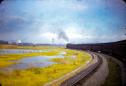
- Doug Debs Date: 02/24/21 19:14 Re: ID help needed. Is this SP steam? Where? Author: norm1153 I reversed it, and attempted to dehaze a little, hope that helps.
 Date: 02/24/21 19:44 Re: ID help needed. Is this SP steam? Where? Author: usmc1401 Could the bridge in the middle be the Oakland terminal.
Date: 02/24/21 19:46 Re: ID help needed. Is this SP steam? Where? Author: ChrisCampi It feels to me the train is on the Milford curling around San Leandro bay heading to Oakland. The airport would be to the left of the train and the white factory looks like Fleismans Yeast along San Leandro blvd. The shadows and breeze would be correct for an afternoon shot.
Date: 02/24/21 22:15 Re: ID help needed. Is this SP steam? Where? Author: MMD To me by the look of the smoke and steam it would appear that the train is in fact setting back, or there is a strong wind blowing at the time, could the train be setting back int a military camp of some sort to either load/unload troops.
Malcolm New Zealand. Date: 02/24/21 22:32 Re: West Oakland Author: timz Think the white structure at right is indeed
the Albers whatever-it-was near Oakland Pier. The water tank was at the Naval Supply Center -- NGS has its lat-lon, which I'll get later. The train will curve left past the semaphores and cross the passenger mains to Oakland Pier above the 7th St underpass. Then maybe it will head southeast toward Niles, or maybe into the coachyard. The tank was at 37.80771N 122.32097W -- it shows on historicaerials pics. Guess that's the Maritime overpass (now gone) just right of the tank. Further right is Yerba Buena Isl, and the Bay Bridge is out of the pic to the right. How common were non-air-conditioned Pullmans in 1948? Edited 4 time(s). Last edit at 02/25/21 10:44 by timz. Date: 02/25/21 01:44 Re: West Oakland Author: ts1457 timz Wrote:
------------------------------------------------------- > How common were non-air-conditioned Pullmans > in 1948? I'd say not common in regular service. Could this be an early Korean War troop train circa 1950 ? Date: 02/25/21 03:02 Re: West Oakland Author: BCHellman timz Wrote:
------------------------------------------------------- > Think the white structure at right is indeed > the Albers whatever-it-was near Oakland Pier. > The water tank was at the Naval Supply Center -- > NGS has its lat-lon, which I'll get later. The > train > will curve left past the semaphores and cross > the passenger mains to Oakland Pier above the > 7th St underpass. Then maybe it will head > southeast toward Niles, or maybe into the > coachyard. > > The tank was at 37-48-27.77 N, 122-19-15.51 W -- > it shows on historicaerials pics. > > Guess that's the Maritime overpass (now gone) > just right of the tank. Further right is Yerba > Buena Isl, > and the Bay Bridge is out of the pic to the > right. > > How common were non-air-conditioned Pullmans > in 1948? Agree on location. Most likely before Desert yard was built, placing the date well before 1946. Date: 02/25/21 08:42 Re: West Oakland Author: DWDebs/2472 In the reversed and de-hazed photo, the Oakland - Yerba Buena Island - San Francisco Bridge is much more clearly visible. The two silver-colored towers of the suspension part of the bridge (Yerba Buena Island to SF) are visible between the red/white checkerboard water tower and the white Albers grain elevators. On the other side of Yerba Buena Island (the "mountain" on the horizon) the latticework cantilever section of the bridge is visible.
- Doug Debs Date: 02/25/21 08:46 Re: ID help needed. Is this SP steam? Where? Author: Conch Thanks to everyone for their input on this. I've added a couple of close ups that might aid in identifying things. In the first view, I noted a white building in the distance above the baggage cars. Any ideas on that? And I also increased the size of the buildings on the left to assist in possible indenification.
I too wondered about the non-AC cars. This slide is a Red Band with only Kodachrome stamped on it so it's pre 1950. It does have a slilde number embossed on the mount (#12) and I don't think they started doing that until after the war sometime. I'm not sure on this so corrections or additons welcome. Thanks again to everyone for their input! Chuck Conway 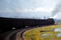 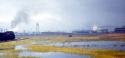 Date: 02/25/21 10:25 Re: West Oakland Author: timz The 1946 Historicaerials pic seems to show
a connection from Desert Yard that would be in plain sight in the pic, connecting where the S-curve reverses direction. It's sort of visible in a 1950s pic All sizes | Boeing C-97A over San Franscico ca1955 NARA342-B-01-017-3-152862AC | Flickr - Photo Sharing! Speaking of Desert Yard -- since it had no engine water, did SP never use steam switchers there? Edited 2 time(s). Last edit at 02/25/21 10:28 by timz. Date: 02/25/21 17:22 Re: West Oakland Author: Elesco timz Wrote:
------------------------------------------------------- > The 1946 Historicaerials pic seems to show > a connection from Desert Yard that would > be in plain sight in the pic, connecting where > the S-curve reverses direction. It's sort of > visible in a 1950s pic > > All sizes | Boeing C-97A over San Franscico ca1955 > NARA342-B-01-017-3-152862AC | Flickr - Photo > Sharing! > > Speaking of Desert Yard -- since it had no engine > water, did SP never use steam switchers there? The West Oakland topographic map dated 1949 also agrees with the above regarding the S-curve and a connection to the Desert Yard. However, the 1931 aerial from the same source shows neither the S-curve nor the Desert Yard. Thus there was no through connection between the Martinez and Niles lines, except possibly by some street running (which I think somebody mentioned last year on this forum). You can see where that might have been be in the 1931 aerial, although it doesn't seem to go all the way through, and the image isn't very sharp. So it apparently the S-curve was built first, followed by the Desert Yard, and the mystery photo was taken in between. |