| Home | Open Account | Help | 264 users online |
|
Member Login
Discussion
Media SharingHostingLibrarySite Info |
Nostalgia & History > The "Foothill" SpursDate: 02/02/11 00:17 The "Foothill" Spurs Author: ats90mph In the Early 20th Century adequate water was obtained in San Bernardino County for agricultural uses. The rocky soil made it perfect for citrus and grape vineyards. The area now known as the "Inland Empire" was primarily agricultural for fifty plus years, until increased tax revenues from homes was more appealing. However the two railroads that ran East-West across the north side of the valley wanted in on the citrus and grape business. To help tap into this business the Santa Fe and Pacific Electric built spurs that ran up steep 3 per-cent grades up into the Foothills. The ATSF called their spurs "Foothill Spurs". At times there were other uses for the branches, such as the quarry off the San Dimas branch on the PE that provided the Pacific Electric with ballast.
Here are the list of the spurs, west to east: PE North San Dimas Spur, Leaves PE San Bernadino Line at Lone Hill in Charter Oak, Serving packing houses in San Dimas, and continuing up to quarry at the mouth of San Dimas Canyon. Crosses ATSF 2nd District at "North San Dimas" (West of Eucla Ave, north of Bonita). PE Orange Heights Spur, Leaves PE San Bernardino Line 1.7 miles east of Claremont at Benson Ave, turned north to what is now the east end of the runway at Cable Airport to serve Smudge Pot oil tanks, also served packing house at Foothill Blvd. PE Upland Packing House Spur, split off PE San Bernardino Line in Upland, Ran south down Euclid Ave. Approx. One Mile to 8th Street with spur east on Stowell Ave, served several packing houses in Upland jointly with ATSF, Crosses ATSF 2nd District in the center of Euclid Ave. Remnants of San Antonio Heights Railway. ATSF Upland Foothill Spur, Leaves ATSF 2nd District Mainline 1.4 miles east of Upland, ran north for 3.7 miles up steep grades to 19th street to serve packing house, several packing houses online. Crosses PE 1.04 miles east of PE Upland Station (Just west of Grove ave). ATSF Cucamonga Foothill Spur, Leaves ATSF 2nd District Mainline 1.9 miles east of Cucamonga, ran north 5.1 miles up to Highland Ave. near Archibald in Alta Loma. Served packing houses and vineyards. Crosses PE San Bernardino Line at Grapeland (Milliken Ave and Current PE Bike trail, Milliken built on Cucamonga Foothill Spur). ATSF Mission Vineyard Spur, left ATSF Cucamonga Foothill Spur just south of Foothill Blvd and ran west 1 mile to winery just past Haven Ave. ATSF Rochester Spur, Leaves ATSF 2nd District 2.7 Miles east of Cucamonga. ATSF Gallo Spur, Leaves ATSF 2nd District 3.1 miles east of Cucamonga, ran 2200 feet across 8th Street to winery. ATSF Muscat Spur, Leaves ATSF 2nd District 1.4 Miles east of Kaiser, ran just over a mile north to Foothill Blvd. ATSF Rialto Foothill Spur, Leaves ATSF 2nd district 0.9 miles west of Rialto, ran north 1.8 miles to military base at what is now Rialto Airport, parallel to Cactus Ave. Crossed PE San Bernardino Line just west of their Rialto Station (Cactus Ave.) Packing house and Military customers online. PE Rialto Packing House Spur, leaves PE San Bernardino Line in Rialto. Ran south down center of Riverside Ave. about a mile to serve packing houses. Former PE line to Riverside. In other parts of Southern California there were other Spurs such as the ATSF Irvine Spur in Orange County. Fell free to add online business, and any spurs I missed. Also important to add there were short spurs along the mainline to serve packing houses that were placed directly on the mainline. (Edited to add content) Edited 6 time(s). Last edit at 02/02/11 05:12 by ats90mph. Date: 02/02/11 03:05 Re: The "Foothill" Spurs Author: scottp "ATSF Rochester Spur, Leaves ATSF 2nd District 2.7 Miles east of Cucamonga."
What is the origin of the name "Rochester"? Does the spur predate the Jack Benny Show's routine about Anaheim, Azusa, and Cuc-amonga? (That first appeared in January 1945; however, funny-sounding southern California names had been highlighted for years before that.) Date: 02/02/11 07:46 Re: The "Foothill" Spurs Author: rehunn The you could add the Santa Fe spurs above Corona off the Elsinore Branch which climbed a short near
3% grade and split into a west spur a mile plus to a packing house and a southerly spur which went another mile or so and split again between two sets of houses. The other more well known and longer lasting spur off the Santa Fe at Arlington Heights, south of Riverside, which ran due east and up a steep grade to serve the Arlington Heights Citrus Association house. Line lasted until the facility burned down, I believe for the second time. Date: 02/02/11 07:50 Re: The "Foothill" Spurs Author: px320 The Cucamonga Foothill Spur ended at Archibald Ave. one-half mile west of the Opici Winery.
This photo was taken on June 21, 1974. Short Line Enterprises 4-4-0 No.8 (ex-D&R #8) and ex-V&T Baggage #21 and Coach combine #8 "Julia bulette" are backing down from the end of track to the Opici Winery. Filming occured on the stretch of track behind the winery. The area in the photo is now all hi end housing. The winery property is now a school. 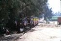 Date: 02/02/11 07:55 Re: The "Foothill" Spurs Author: rehunn The spur that Stan occupied crossed Foothill Blvd to a switch, one leg went toward "Cucamonga Foothill"
which is about where the train is shown and the other leg went straight north into somewhere up near where Chaffey College is presently located. Date: 02/02/11 09:01 Re: The "Foothill" Spurs Author: px320 rehunn Wrote:
------------------------------------------------------- > The spur that Stan occupied crossed Foothill Blvd > to a switch, one leg went toward "Cucamonga > Foothill" > which is about where the train is shown and the > other leg went straight north into somewhere up > near where > Chaffey College is presently located. The switch on the north side of Foothill Blvd led to the Virginia Dare Winery on the NW corner of Foothill and Haven. The spur itself crossed Foothill about 1/2 mile east of Haven Ave. The spur continued due north for more than a mile crossed the PE and continued north for some distance where it turned west to Haven Ave. At Haven Ave. the spur turned north and ran down the middle of the road to Highland Ave. where it again turned west and continued past the Opici Winery at Turner Ave. and on to the end of track at Archibald Ave. It was located half way between Highland and Lemon avenues. The picture was taken about 1/4 mile from the end of track. Edited 1 time(s). Last edit at 02/02/11 09:06 by px320. Date: 02/02/11 12:05 Re: The "Foothill" Spurs Author: rehunn To Stan's post, after crossing Foothill there was a switch, his leg went west and paralleled Foothill,
and another leg went north, never did walk it but it continued due North toward Chaffey College for some distance. Date: 02/02/11 12:35 Re: The "Foothill" Spurs Author: px320 Here's a map that may help.
The red line is the Cucamonga Foothill Spur. The line that parallels Foothill goes to the Virginia Dare Winery. I noticed that Turner ave. has had it's name changed to Hermosa. The Black line is the old PE. 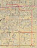 Date: 02/02/11 12:43 Re: The "Foothill" Spurs Author: rehunn Where the line curves along what is shown as "Menlo", right at that curve was a switch and track continued north for some
distance and does not show on any maps. Date: 02/02/11 14:07 Re: The "Foothill" Spurs Author: px320 That switch was not there in 1967 when we leased the last half mile of the spur.
Date: 02/02/11 15:19 Re: The "Foothill" Spurs Author: mundo Looking for maps that show all the spurs in South Corona, that came off the
Elsinore branch. Served several packing houses and a smudge oil facility. Details were never included in operating timetables, general bulletin's did say, that brakeman would ride on top of cars account the 3% grade. all retainers had to be set. Date: 02/02/11 15:49 Re: The "Foothill" Spurs Author: rehunn I somewhere have a Thomas Bros Atlas from like 1967 that actually shows the trackage. I could probably draw
it from memory, never saw it used after about July of 1967 other than a whole work train parked just south of the old 71 crossing in late 67. Line was well built, decent rail, good ties and hardly looked like some out of the way spurs to remote packing houses. Date: 02/02/11 16:40 Re: The "Foothill" Spurs Author: lwilton px320 Wrote:
------------------------------------------------------- > I noticed that Turner ave. has had it's name > changed to Hermosa. Happened not too long after Cocamonga became Rancho Cucamonga. Actually the street always was (or at least since the 1950s was) Hermosa north of 19th, and was Turner south. Now it is Hermosa in all of RC, and changes back to Turner at 4th St in Ontario, where it continues south under that name for about a block and a half until cut by the 10 freeway. It then contines for another block and half or so south of the freeway until cut again by the airport during the second runway extension to the east. There was a remaining half block or so south of the airport, but that became essentially a private road and private drive into a rather large vineyard house there. You could still get to it, but with difficulty. After 9/11 it was sealed on the north end, and is now just a gated driveway to the house. I don't recall if Turner ever reached Mission, but if so, it no longer does. Date: 02/02/11 17:31 Re: The "Foothill" Spurs Author: DNRY122 One of the Pacific Electric legends I've heard several time was about the "oil trains" that would run from the refinery in El Segundo to the tank farms in places like Orange Heights. According to the story, on really cold nights, when the growers started "firing" the orchard heaters early, and kept them going until dawn, if the fuel oil supply out in the "Orange Empire" was running low, PE would run solid trains of tank cars (nowadays they'd be "unit trains") to the citrus areas, and they'd have rights over EVERYTHING. One version of the story is that when the trains went through downtown LA on San Pedro St., LAPD stopped traffic to let them roll unencumbered to the vital growing areas. I vaguely recall an electrified track crossing Foothill Blvd. out near Upland at grade (so it wasn't the main line which had the bridge over the "subway"), and I later learned its purpose. I was old enough to note that it was "catenary" rather than "direct suspension" (the latter construction was the type found on the Monrovia line next to my house).
Date: 02/02/11 18:31 Re: The "Foothill" Spurs Author: px320 This is a shot of the siding and engine house we built at the far end of the spur. This was taken about July of 1968.
In the background you can see the reason for the spur to go as far as Archibald Ave. That's a smudge oil storage tank you see. 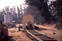 Date: 05/29/11 13:15 Re: The "Foothill" Spurs Author: MyfordBrowning From the 60's I checked out the Cucamonga Foothill Spur several times and I never saw a connection north of Grapeland nor any map, including topo maps that showed a line there.
By the time that I was looking at the spur there was no existing visiable reason for such a long line. Cliff Date: 08/19/23 10:59 Re: The "Foothill" Spurs Author: Site_Steward Rehunn,
If that switch and extended track does not appear on any maps, I am very curious what is your source of that info? That swtich does not even appear on the 1953 topp map either just as Stan said it was not there when they moved in.. However, I do see a slight countiur at that location on the map that could indate such a RR grade existed. Thanks. Lance rehunn Wrote: ------------------------------------------------------- > Where the line curves along what is shown as > "Menlo", right at that curve was a switch and > track continued north for some > distance and does not show on any maps.  |