| Home | Open Account | Help | 281 users online |
|
Member Login
Discussion
Media SharingHostingLibrarySite Info |
Nostalgia & History > RR Terminal track plansDate: 06/30/11 15:29 RR Terminal track plans Author: glcaddis Is there a source that shows the tracks coming into RR Stations back in the heyday of passenger service. I would love to see what all the terminals in Chicago looked like track-wise. The photos I've seen of these terminals don't show enough detail for my curiosity. For example, I'd like to know how many tracks at Dearborn Station and what roads used which tracks. Because I used KC Union Station a lot when I was a kid, I'd love to know similar details for it. Is there any hope?
Date: 06/30/11 16:12 Re: RR Terminal track plans Author: WAF There used to be a huge map from the 50s for the RR rate bureaus that showed everything in detail
Date: 06/30/11 19:23 Re: RR Terminal track plans Author: Panamerican99 Look for Sanborn maps. They have most details, including buildings, shops, even houses.
Date: 06/30/11 19:36 Re: RR Terminal track plans Author: Out_Of_Service glcaddis Wrote:
------------------------------------------------------- > Is there a source that shows the tracks coming > into RR Stations back in the heyday of passenger > service. I would love to see what all the > terminals in Chicago looked like track-wise. The > photos I've seen of these terminals don't show > enough detail for my curiosity. For example, I'd > like to know how many tracks at Dearborn Station > and what roads used which tracks. Because I used > KC Union Station a lot when I was a kid, I'd love > to know similar details for it. Is there any > hope? http://www.historicaerials.com/aerials.php?code=404 ... type in KANSAS CITY UNION STATION and use the slide at the bottom right to zoom out and refix what you want to check out ... choose 1959 it's probably the best year to look at what you want to see ... left click and hold to move map in any direction ... on the big map of the US the shaded areas are the ones that the map allows for previous years ... 1952 would be the best year for CHICAGO UNION STATION ... the other downtown stations are to the right across the river ... just click and move the map left or zomm out and refix your position and zoom in again Edited 4 time(s). Last edit at 07/01/11 04:09 by Out_Of_Service. Date: 06/30/11 19:47 Re: RR Terminal track plans Author: 1stcajon Panamerican99 Wrote:
------------------------------------------------------- > Look for Sanborn maps. They have most details, > including buildings, shops, even houses. Do you have a way to get into Sanborn maps? Used to have login info but it';s no good anymore. They are good for buildings & such but the track info given is not always very accurate given they didn't insure them. Date: 06/30/11 22:10 Re: RR Terminal track plans Author: peddler Here is a diagram of Dearborn Station. Not the best but it is all I have.
As I recall, the tracks most commonly used were: Santa Fe ... 2-3-4-5 GTW ... 2-3-4 CEI ... 2-3-4 WAB ... 5-6-7-8 EL ... 5-6-7-8-9 Monon ... 7-8-9 CWI ... 8-9 peddler Edited 2 time(s). Last edit at 06/30/11 22:15 by peddler. 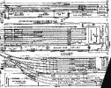 Date: 12/06/19 19:06 Re: RR Terminal track plans Author: kentishtim Thanks for posting the track maps! Could you provide a source for these?
There are a couple of other posted on the Industrial History website, but with no source: http://industrialscenery.blogspot.com/2018/05/chicago-eastern-illinois-freight-houses.html Cheers everyone for making this topic fascinating! |