| Home | Open Account | Help | 269 users online |
|
Member Login
Discussion
Media SharingHostingLibrarySite Info |
Nostalgia & History > Port of Oakland: Outer Harbor and the Army Base ResearchDate: 01/05/21 22:13 Port of Oakland: Outer Harbor and the Army Base Research Author: phthithu I posted a while back about this subject and got some helpful replies. Here's some further research I've done on the area. It's an area rich in history but you'd be hard-pressed to find much of it today. Here are three pictures of remnants from a largely unhelpful reconnaissance over the weekend.
All three pictures are on or jsut off Maritime. Pic 1 is a crossing signal. 2 and 3 are at the corner of Vukasin Way and Maritime. The track in 2 was the OTR, earlier Key System, lead from their trackage on the south side of the Bay Bridge approach. I'm not totally sure if the OTR had access to just one track here or all of the tracks, there were a few tracks running along Maritime here along with a lead into the Army Warehouse area across Maritime which leads me to believe most of the tracks were part of the Army's railroad. Key System ran through here before the Army arrived, and presumably the Army installed a lot of rail in WWII as this base was a major part of the Army's transportation system The track seen in pic 3 curves off the track seen in pic 2. It went to a wharf called the Wharf St. wharf and it also curved north to serve a wharf there and then reconnect to the Key System yard. Next to the building in this picture is a warehouse that dates back to at least 1931. The curving track was Key and later OTR only while everything past the switch in pic 2 appears to have been SP-OTR joint switching facility, with the SP owning the lead along Maritime shared with OTR. Reason for this was that the SP used to connect to the Outer Harbor lead using a lead that crossed from their main around 16th St. to the Port. Kind of confusing I know. See next post. Edited 1 time(s). Last edit at 01/05/21 22:16 by phthithu. 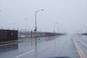 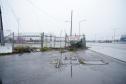 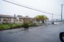 Date: 01/05/21 22:29 Re: Port of Oakland: Outer Harbor and the Army Base Research Author: phthithu Here's a map from the Port Series document from 1939. All these Port Series documents at Hathi Digital Trust or Google Books are very helpful but they never have the maps inside them scanned. Luckily this one was posted at the Online Archive of California. Click on the image to enter the zoom window: https://calisphere.org/item/ark:/13030/kt367nd26b/
Below the map is a 1931 aerial of the Outer Harbor and the future site of the Army Base and SP's Desert Yard. I marked 16th Street station in it. There are two leads from the Key System yard into the part. Question: are they both Key leads? This detail comes from the following photo at the UCSB Special Collections Library via their Framefinder webapp. This is a direct download link and it's a 230MB file: http://mil.library.ucsb.edu/ap_images/c-1600/c-1600_15.tif The sixth pic is a view from 1965 showing same area for reference. Also from the UCSB Special Collections Library via Framefinder and the direct download link (25MB file) is http://mil.library.ucsb.edu/ap_images/cas-65-130/cas-65-130_15-6.tif 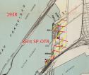 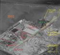 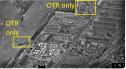 Date: 01/05/21 22:38 Re: Port of Oakland: Outer Harbor and the Army Base Research Author: phthithu Here's a 2001 map from the Oakland Army Base disposal and resuse draft EIS. It shows what areas the Army owned. They leased some of this land to other parties, and also leased land from the Port of Oakland, too. I know both SP and OTR leased tracks in the railyards. This is via Hathi Trust: https://catalog.hathitrust.org/Record/100981308
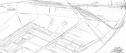
The broad question I have is where the OTR operated in the northern part of the Outer Harbor in the 1960s and 70s because the leads they operated over had to have been shared with the Army. In the 1974 Port Series document there's an entry for the wharf north of Wharf St. as being served by OTR(Berth 10). Back in 1963 that wharf wasn't listed, which I believe means it was being used by the Army. They don't mention the Army stuff in the Port Series documents. Edited 2 time(s). Last edit at 01/05/21 23:25 by phthithu. 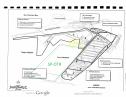 Date: 01/05/21 22:59 Re: Port of Oakland: Outer Harbor and the Army Base Research Author: phthithu Here's the lower part of the Outer Harbor from 7th St. north. The buidlings with the crossed out green question marks were Oakland Army Base buildings (OAB). A lead from the OAB's Knight Yard reached spurs to these buildings' loading docks from the east while the same spurs connected on the west with the SP-OTR lead along Maritime. These spurs are drawn on the 1980ish SPINS but have no track number so not sure what the deal was with them. Perhaps the Army had access to the Maritime St. lead down here when these buildings were built.
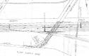
 Date: 01/05/21 23:19 Re: Port of Oakland: Outer Harbor and the Army Base Research Author: phthithu Here's the northern part of the Outer Harbor, inner portion, showing at the bottom the curve seen in picture 2 in first post. I have drawn in what I feel might be the OTR's routes to switch this area in the 1965-1970s era.
I marked the Berth 10 which was Port of Oakland property presumably leased by Army and then leased by a commercial venture by the 1970s or perhaps earlier. "The West Lead" is a term from the 2001 EIS. They mentioned that the OTR or ATSF rather owned the West Lead but shared it with the OAB. https://hdl.handle.net/2027/ien.35556033434812?urlappend=%3Bseq=178 Edited 1 time(s). Last edit at 01/05/21 23:25 by phthithu. 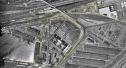 Date: 01/06/21 08:30 Re: Port of Oakland: Outer Harbor and the Army Base Research Author: FiveChime Here is a little video of OT 97 running on some of the mentioned in this posting.
Regards, Jim Evans You must be a registered subscriber to watch videos. Join Today! Date: 01/06/21 08:49 Re: Port of Oakland Author: timz The last three aerials are 1965?
Wonder if the "1938" map is correct in not showing the balloon curve from the Cal-P to W Oakland yard. Always suspected that was built as part of the preparation for the SP-electric move to tbe Bay Bridge. Date: 01/06/21 10:34 Re: Port of Oakland Author: phthithu Fantastic video Fivechime. Thanks for sharing. I haven't seen much Maritime Street pictures this one was way better than a picture.
Now based on Rantoul's posting this trackage had catenary over it at one time. I would have enjoyed seeing a shot of the Key/OTR on the oil pier under catenary. Date: 01/06/21 11:19 Re: Port of Oakland: Outer Harbor and the Army Base Research Author: Evan_Werkema phthithu Wrote:
> Here's the lower part of the Outer Harbor from 7th > St. north. The buidlings with the crossed out > green question marks were Oakland Army Base > buildings (OAB). You're missing the bottom part of the OTR lead along Maritime, just visible in the aerial, which curved across 7th and joined the SP tracks. That is the curve you see OTR 2197 negotiating at the beginning of FiveChime's video, and the curve OTR 97 is about to enter in this photo: https://www.trainorders.com/discussion/read.php?11,2477099,2477443#2477443 FiveChime has some more footage I don't believe he's posted showing 2197 switching a customer about where your "OTR Lead" pointer is pointing, but it accessed that customer via a lead coming up from 7th and across that unidentified street one block west of Maritime. Try as I might, I've never been able to find documentation or photos showing catenary any further south than the Union Construction Co. shipyard at the north end of the Outer Harbor, which was located under your "Key only" marker on the 1931 aerial. The shipyard opened right around the time of the WWI armistice in 1918, well before the rest of the Outer Harbor development began in the early 1930's. The lead to Union Construction is clearly marked in this 1930 map of Key System team tracks and industry spurs, but the shipyard had closed by then, so it's not identified as an active customer: https://www.trainorders.com/discussion/read.php?11,4299254,4299328#4299328 When serious development of the Outer Harbor got underway a few years later, Key System bought a steam locomotive to switch it, suggesting that most of the trackage was non-electrified. Photos of rail operations in the port area are scarce, but I've seen a photo of a Key System-era Oakland Terminal RR office at the foot of 14th St, and there is no catenary in the photo. There is also no overhead in this photo of OTRR #4 at work at one of the transit sheds: https://www.trainorders.com/discussion/read.php?10,4572210 Don't know if you've come across it yet, but there's an old aerial photo from the early 1930's overlooking the Outer Harbor in this old thread that you might find interesting: https://www.trainorders.com/discussion/read.php?11,4079283,4079730#4079730 In the 70's, 80's, and 90's, the OTRy definitely had trackage rights all the way down what was left of the SP 7th St. track past the Albers Mill. Photographic documentation of the OTRy in the 1960's, unfortunately, has proven very elusive. Even roster shots of the locomotive tied up under the Bay Bridge approaches from that decade are scarce, let alone photos of it out working. Date: 01/06/21 12:24 Re: Port of Oakland: Outer Harbor and the Army Base Research Author: Westbound The 1980 book Red Trains Remembered by Robert S. Ford contains almost no information about the OTR. It does have a great photo on page 88 of a 2 car SP electric passenger train passing over the SP mainline on the 26th Street Viaduct (southerly half), north of the old SP depot on Wood Street. That entire viaduct had catenary wire. In later years the rails were removed on the southerly half of the viaduct and it was used just as a private road (by the OTR?). The northerly half of the viaduct was used by the OTR. Don't know if the SP ever used it, but I saw only OTR trains on it.
You have done some good research, Phthiti ! Edited 1 time(s). Last edit at 01/06/21 12:25 by Westbound. Date: 01/06/21 12:51 Re: Port of Oakland: Outer Harbor and the Army Base Research Author: Evan_Werkema Westbound Wrote:
> The 1980 book Red Trains Remembered by Robert S. > Ford contains almost no information about the OTR. > It does have a great photo on page 88 of a 2 car > SP electric passenger train passing over the SP > mainline on the 26th Street Viaduct (southerly > half), north of the old SP depot on Wood Street. > That entire viaduct had catenary wire. By the time the OTR started using the northerly half, the wire had been taken down: https://www.trainorders.com/discussion/read.php?1,3471368,3471430#3471430 > In later years the rails were removed on the southerly half > of the viaduct and it was used just as a private > road (by the OTR?). The southerly half was converted into an access road for the Oakland Army Base. The OTR office and tie-up point continued to be at Hannah St. near the former Key System Yerba Buena Yard up until the 1980's. > The northerly half of the > viaduct was used by the OTR. Don't know if the SP > ever used it, but I saw only OTR trains on it. I've never been able to track down how that flyover came to be used by OTR. For a while after the sale to WP and Santa Fe, the OTR had trackage rights through the Key System subway. They were using the flyover by the late 1940's and ownership did get transferred at some point. The only SP locomotives I've ever seen on it were ones borrowed by the OTR in the 1980's when Baldwin 101 was sick. Date: 01/06/21 12:56 Re: Port of Oakland: Outer Harbor and the Army Base Research Author: phthithu Evan,
Thanks for this great reply. OTRR Lead Looks like I erred on that OTRR lead markup int he 1965 photo. The SPINS(it's circa 1980ish) shows what you say--track 300, which appears to run along south side of 7th St., is marked as "OTRR lead" and 301 is listed as "OTRR lead" on the track list. Both 300 and 301 run in parallel out to the "Outer Harbor Terminals" which I believe is the area around the former SP mole--a different area really from the "Outer Harbor" that I'm looking at here but I guess the term "Outer Harbor" had kind of shifted south a bit to include the terminal built over the SP mole by the 70's. Or maybe not--the SP mole site sort of a divider area between Middle and Outer Harbors I guess. One question this raises: in the period between the abandonment of the SP's Oakland Pier and the redevelopment of the site by the Port of Oakland, did the OTR use the portion of the Maritime St. lead which crossed 7th. and joined the SP? They could have used it to get to Albers/Carnation and to interchange with the SP. Catenary Well another mystery I guess. Rantoul posted some plat maps of the Outer Harbor, not dated but showing the OAB in situ, which had a note for the Maritime St. lead at Petroleum St. as follows: "The Oakland Terminal Railroad owns overhead electrification and bonding only/Track Owned by So. Pac. RR". Perhaps Rantoul will post these plat maps (I tried but couldn't find them but had saved one for reference). Thanks for providing that Union Construction Co. information. I was looking at that area last night and thought that looked like a shipyard's ways there. Interesting that it was already out of business by then. I have to digest the other sources you posted and will post further later. Thanks again for you help! Edited 1 time(s). Last edit at 01/06/21 17:37 by phthithu. Date: 01/06/21 13:14 Re: Port of Oakland: Outer Harbor and the Army Base Research Author: phthithu Thanks for checking Red Trains Remembered, Westbound. Based on the aerials I suspect the SP would have access the Army's Knight Yard via a connection off Desert Yard as well as via the tracks on Maritime all the way up to today's Vukasin Way which was where the SP used to connect to Maritime St. crossing the mudflats a point between 16th St. tower and the signal bridge just north of there.
Westbound Wrote: ------------------------------------------------------- > The 1980 book Red Trains Remembered by Robert S. > Ford contains almost no information about the OTR. > It does have a great photo on page 88 of a 2 car > SP electric passenger train passing over the SP > mainline on the 26th Street Viaduct (southerly > half), north of the old SP depot on Wood Street. > That entire viaduct had catenary wire. In later > years the rails were removed on the southerly half > of the viaduct and it was used just as a private > road (by the OTR?). The northerly half of the > viaduct was used by the OTR. Don't know if the SP > ever used it, but I saw only OTR trains on it. > > You have done some good research, Phthiti ! > 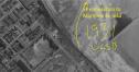 Date: 01/06/21 13:57 Re: Port of Oakland: Outer Harbor and the Army Base Research Author: phthithu Scroll up one page to see Key System Mole and scroll down to see some other photos of Port of Oakland in thie 1933 Port Series book at Hathi Trust Digital Library: https://hdl.handle.net/2027/ien.35556041839820?urlappend=%3Bseq=256
1933 view of the original Outer Harbor Terminal including the oil pier (Parr Terminal according to the document). Not seeing anything in here that suggests catenary out here: https://hdl.handle.net/2027/ien.35556041839820?urlappend=%3Bseq=258 Here's the section from this same document with the table of wharves/piers. Note Albers wasn't served by Key at this time, but was later. Thinking about the catenary, I guess it makes sense that there would no catenary near the port due to the nature of unloading and loading ships on the wharves. But were there ports who used catenary on wharves? Date: 01/06/21 17:07 Re: Port of Oakland Author: phthithu timz Wrote:
------------------------------------------------------- > The last three aerials are 1965? > > Wonder if the "1938" map is correct in > not showing the balloon curve from the Cal-P > to W Oakland yard. Always suspected that > was built as part of the preparation for > the SP-electric move to tbe Bay Bridge. Good question. That 7th st. curve might also be related to construction of Desert Yard. Anyone know when that happened? Here's detail from one of the 1931 frames at UCSB's Framefinder site: Edited 1 time(s). Last edit at 01/06/21 17:12 by phthithu. 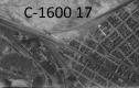 Date: 01/07/21 05:19 Re: Port of Oakland Author: rantoul .
   Date: 01/07/21 05:20 Re: Port of Oakland Author: rantoul OTR
   Date: 01/07/21 20:24 Re: Port of Oakland Author: Evan_Werkema Thanks for the plats, rantoul. I see there's a date in the lower right corner of the first one, but can't quite read it. Can you make it out on your original scan?
Date: 01/08/21 05:20 Re: Port of Oakland Author: rantoul Evan_Werkema Wrote:
------------------------------------------------------- > Thanks for the plats, rantoul. I see there's a > date in the lower right corner of the first one, > but can't quite read it. Can you make it out on > your original scan?  Date: 01/08/21 10:57 Re: Port of Oakland Author: phthithu Thanks Rantoul. Great stuff.
|