| Home | Open Account | Help | 365 users online |
|
Member Login
Discussion
Media SharingHostingLibrarySite Info |
Canadian Railroads > Looking for Information on Abandoned CP Line in NBDate: 01/15/22 14:02 Looking for Information on Abandoned CP Line in NB Author: SD80MACfan I'm doing research on the Canadian Pacific lines that crossed New Brunswick and have stumbled upon a mystery. There was a line that travled from Woodstock Junction, near Jennings Falls on the line from Fredericton to Woodstock, that travled northwest to Hartford. All these lines are now abandoned. It appears the northern half of this line was converted into a road, E Brighton Rd, but I cannot find a good map showing where the old line connected with the north-south mainline in Hartford. All Google searches either come up with low-detail topographical maps that only confirm what I already know, or of the town of Hartford in Devon, UK. Any help from people that know the line or are from the area would be helpful.
EDIT: The town was actually Hartland, not Hardford. My bad. Edited 2 time(s). Last edit at 01/17/22 19:30 by SD80MACfan. Date: 01/15/22 20:10 Re: Looking for Information on Abandoned CP Line in NB Author: LKeithR Have you tried looking on Google Earth. There is what appears to be an abandoned railroad line that runs
out of Woodstock and parallels whatever river that is before crossing Red Bridge Rd. a mile or two west of Hartford. It's marked with a dotted line so I assume it's a designated trail of some sort... Keith Robertson Langley, BC Date: 01/15/22 21:19 Re: Looking for Information on Abandoned CP Line in NB Author: SD80MACfan LKeithR Wrote:
------------------------------------------------------- > Have you tried looking on Google Earth. There is > what appears to be an abandoned railroad line that > runs > out of Woodstock and parallels whatever river that > is before crossing Red Bridge Rd. a mile or two > west of > Hartford. It's marked with a dotted line so I > assume it's a designated trail of some sort... I have, but the issue is there's two lines. At Woodstock Junction there was a wye for trains traveling east out of Fredericton to go northwest to Hartland and on to Quebec City or to go southwest to Woodstock and Houlton, Maine. I can clearly see where the line to Woodstock joined up with the main along the St. John River, but I can't tell where the line to Hartland joined up. Hartland to Woodstock Jct to Woodstock was basically one giant wye that spanned several miles across. Edited 1 time(s). Last edit at 01/17/22 19:31 by SD80MACfan. Date: 01/15/22 22:23 Re: Looking for Information on Abandoned CP Line in NB Author: moonliter SD80MACfan Wrote:
------------------------------------------------------- >> LKeithR Wrote: > > Have you tried looking on Google Earth. >> It's marked with a dotted line so I > > assume it's a designated trail of some sort... You wrote: > I have, but the issue is there's two lines. At > Woodstock Junction there was a wye for trains > traveling east out of Fredericton to go northwest > to Hartland and on to Quebec City. Did you make the name "Woodstock Jct" up for the point near Jennings Falls? I see the two dotted lines for the NB Trails, the dotted line that went to Woodstock was the CPR line, the other that went towards Hartford might have been a logging road or even onetime a private logging railroad that was also converted to a trail. I have not read or seen anything the it was a railway. The CP line ended at Edmundston,NB. It was the NTR today's CN that continued on to Quebec City. Gerry Gaugl Ottawa ON Date: 01/16/22 05:16 Re: Looking for Information on Abandoned CP Line in NB Author: SD80MACfan No I did not make the name up. In my research I found a map of all the major rail lines in New Brunswick that shows that specific junction named as Woodstock Jct. And it shows a line traveling north from that point to connect with the CP line in Hartland. The map is found here: https://web.lib.unb.ca/archives/finding/ketchum/nb_railway.html
I have not, however, found this name on any other map like most of the other junctions in the region. Edited 1 time(s). Last edit at 01/17/22 19:32 by SD80MACfan. Date: 01/16/22 08:47 Re: Looking for Information on Abandoned CP Line in NB Author: domerider400 I apologize if you already checked this, but there is an Android app, "Rail Guide", that I've often used. There are multiple map layers, including, "Current", "Classic", and "Abandoned" which are helpful. It gets an ocaissional update to include more former rail lines. See -
https://play.google.com/store/apps/details?id=com.railguide.rg_free Bob P Posted from Android Date: 01/16/22 10:23 Re: Looking for Information on Abandoned CP Line in NB Author: SD80MACfan domerider400 Wrote:
------------------------------------------------------- > I apologize if you already checked this, but there > is an Android app, "Rail Guide", that I've often > used. There are multiple map layers, including, > "Current", "Classic", and "Abandoned" which are > helpful. It gets an ocaissional update to include > more former rail lines. See - > > https://play.google.com/store/apps/details?id=com. > railguide.rg_free > > Bob P > > Posted from Android I had not but thank you for this. It will come in very handy for other projects. Unfortunately for me, in looking at my problem area, the "abandoned" layer only confirms what I already know, that the line did travel the route of the road, and it stops where the road stops. It does not show where it connected with the mainline, even though it's all but obvious that it connected at one point. Date: 01/16/22 10:26 Re: Looking for Information on Abandoned CP Line in NB Author: moonliter SD80MACfan Wrote:
------------------------------------------------------- > No I did not make the name up. In my research I > found a map of all the major rail lines in New > Brunswick that shows that specific junction named > as Woodstock Jct. And it shows a line traveling > north from that point to connect with the CP line > in Hartford. The map is found here: > https://web.lib.unb.ca/archives/finding/ketchum/nb > _railway.html > > I have not, however, found this name on any other > map like most of the other junctions in the > region. I'm in the same boat, that is why I asked if the name of the junction was made up. I checked my timetables, books on New Brunswick railways, and Andreae's "Lines of Country. An Atlas of Railway & Waterway History of Canada", still no luck. Thank-you for posting the link because it was there I found a clue to help solve this mystery. The name on the bottom of the map is James A. Clowes who I knew as "Art". He is very interested in railways in Canada in but his vast wealth of knowledge goes back to the 1800's unlike many others who concentrate post 1930's railway history. Unfortunately, Art passed in 2021. Seeing Art's name on the bottom of the map suggested that there might be merit in the point called Woodstock Jct. Instead of focusing on the New Brunswick Railway I figured this may have been a logging railway. This lead me to NB's Facility Act of 1864 offering developers $10,000.00 per mile of new railway construction. The only problem was that the colony was broke so 10,000 acres of free land in lieu of cash was offered. One Mr. Alexander Gibson took up the offer and created a railway and lumber empire. After finding nothing about the line searching under New Brunswick Railway, I looked up information on Mr. Gibson and there I saw the name Woodstock Jct in an article titled "Boss" Gibson's First Railroad" Here is the link: https://johnwood1946.wordpress.com/2017/05/17/boss-gibsons-first-railroad/ Hope this helps you out, your question kept me indoors where our outdoor temperature is -18.4 degrees Fahrenheit today, thank-you. Gerry Gaugl Ottawa ON Date: 01/16/22 10:40 Re: Looking for Information on Abandoned CP Line in NB Author: SD80MACfan moonliter Wrote:
------------------------------------------------------- > SD80MACfan Wrote: > -------------------------------------------------- > ----- > I'm in the same boat, that is why I asked if the > name of the junction was made up. I checked my > timetables, books on New Brunswick railways, and > Andreae's "Lines of Country. An Atlas of Railway & > Waterway History of Canada", still no luck. > Thank-you for posting the link because it was > there I found a clue to help solve this mystery. > The name on the bottom of the map is James A. > Clowes who I knew as "Art". He is very > interested in railways in Canada in but his vast > wealth of knowledge goes back to the 1800's unlike > many others who concentrate post 1930's railway > history. Unfortunately, Art passed in 2021. > Seeing Art's name on the bottom of the map > suggested that there might be merit in the point > called Woodstock Jct. > > Instead of focusing on the New Brunswick Railway I > figured this may have been a logging railway. > This lead me to NB's Facility Act of 1864 offering > developers $10,000.00 per mile of new railway > construction. The only problem was that the > colony was broke so 10,000 acres of free land in > lieu of cash was offered. One Mr. Alexander > Gibson took up the offer and created a railway and > lumber empire. After finding nothing about the > line searching under New Brunswick Railway, I > looked up information on Mr. Gibson and there I > saw the name Woodstock Jct in an article titled > "Boss" Gibson's First Railroad" > > Here is the > link: https://johnwood1946.wordpress.com/2017/05/ > 17/boss-gibsons-first-railroad/ > > Hope this helps you out, your question kept me > indoors where our outdoor temperature is -18.4 > degrees Fahrenheit today, thank-you. > > Gerry Gaugl > Ottawa ON Thank you for the article. It does confirm that the line did in fact connect in Hartland. But Hartland is so overbuilt that the old grade is all but invisible. This line must have been gone for a while. I'm not even seeing it in maps from the 1950s but the road is there. Curious as to why CP (or whoever owned it at the time) would have abandoned that portion; seems like it would have been good competition for the CN line to the north. I wish there were more detailed topographical maps or atlases available of that area that actually show wyes and sidings like those on Historic Aerials website. But I'll try to do some more digging now that I have some more references available. Edited 1 time(s). Last edit at 01/17/22 19:33 by SD80MACfan. Date: 01/16/22 12:04 Re: Looking for Information on Abandoned CP Line in NB Author: Magellan13 There may have been some confusion when the town "Hartford" was mentioned. I think you meant "Hartland" in all cases. There is, in fact, a "Hartford" just northwest of Woodstock on the west side of the river, that the ex-CN line to Centreville passed through. But that does not appear to be the line you are talking about. The copy of the "SPV Comprehensive Railroad Atlas of North America: New England & Maritime Canada" by Mike Walker that I have shows that line you are referring to, but the station names are different. Woodstock Junction is shown as being the junction point along the river between Hartland and Deep Creek (the north end of that segment). The southern end, the one labelled as "Woodstock Junction" on the map you have shared, appears to be listed as "Shewan".
Is it possible that "Shewan" was actually named "Woodstock Junction" when the New Brunswick Railway owned the lines, denoting where the Woodstock Branch diverged west from the main line through Hartland and points north. But when those lines were taken over by CP, CP may have moved the name Woodstock Junction to refer to the junction point where the river valley line diverges south to Woodstock? CP would then have renamed the "old" Woodstock Junction to "Shewan"? (just a hypothesis) Magellan13 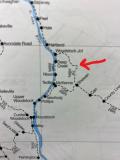 Date: 01/16/22 12:13 Re: Looking for Information on Abandoned CP Line in NB Author: moonliter There could be many reasons for the change, lots of changes in technologies, traffic patterns, consolidations, etc. It would be interesting to find out when the junction ceased to be. The CPR ETT dated June 26, 1892 has no mention of Woodstock Jct but shows a connection of the Gibson Section and the Aroostook Section at a point called Newburg JC. (wording & spelling as printed on the document)
Gerry Gaugl Ottawa ON Date: 01/16/22 12:23 Re: Looking for Information on Abandoned CP Line in NB Author: moonliter Magellan13 Wrote:
------------------------------------------------------- > The > copy of the "SPV Comprehensive Railroad Atlas of > North America: New England & Maritime Canada" by > Mike Walker that I have shows that line you are > referring to, but the station names are > different. Woodstock Junction is shown as being > the junction point along the river between > Hartland and Deep Creek (the north end of that > segment). The southern end, the one labelled as > "Woodstock Junction" on the map you have shared, > appears to be listed as "Shewan". > > Is it possible that "Shewan" was actually named > "Woodstock Junction" when the New Brunswick > Railway owned the lines, denoting where the > Woodstock Branch diverged west from the main line > through Hartland and points north. But when > those lines were taken over by CP, CP may have > moved the name Woodstock Junction to refer to the > junction point where the river valley line > diverges south to Woodstock? CP would then have > renamed the "old" Woodstock Junction to > "Shewan"? (just a hypothesis) I see that you have an up-dated copy of the Atlas, my 1999 edition does not show the jct. Gerry Gaugl Ottawa ON Date: 01/16/22 22:11 Re: Looking for Information on Abandoned CP Line in NB Author: Magellan13 You've piqued my interest.
There is some more info on the Wikipedia page for the "New Brunswick Railway". The only reference showing is "Narrow Gauge Railways of Canada" by Omer Lavallee, so I presume that the information comes from that source. I don't have that book in my library so cannot verify its accuracy. However, what it says is.... "The 1881 conversion of the NBR to standard gauge track, followed by the 1882 purchase of the New Brunswick and Canada Railway saw a 9.5 mile (15.3 km) section of the NBR's original narrow gauge line between Shewan and Hartland abandoned. A new line was built from Shewan west to the east bank of the Saint John River at Newburg where it joined a new line being built by the NBCR at Debec via Woodstock where it crossed to the east bank of the Saint John River and on to Hartland." So that would seem to suggest the line was abandoned some time after 1882, and the northern end of that segment (near Hartland) may not have actually had an operable "junction" if the line to Shewan was abandoned as the line between Hartland and Newburg opened. However, the Provincial Archives of New Brunswick suggest that "Newburg Junction" became a place in 1873 when the Woodstock Branch was connected to the Gibson line of the CPR (!). So the dates don't match up here, nor does the timeline for when the CPR took over (which I believe was 1890. But there is a great resource at the link below for a Word Document on the History of Carleton County that indicates how that triangle of railroads appears to have been built. It seems the junction point of Shewan was originally called Newburg.. After a section discussing the original narrow-gauge bridge across the river to Woodstock and the later standard-gauge bridge at Upper Woodstock, it has the following passage: "The grades on this road were very steep, both going up to Newburg Station and coming out of Hartland, and the Railway Company changed their roadbed and built it down near the river, all the way from Hartland to Woodstock, and changed Newburg Station again, down near the Upper Woodstock bridge. The old Newburg Station was called Shewen. And the high Archer’s Creek bridge was dismantled." So from what I can see, it looks like the narrow gauge line split at what was called Newburg (later Shewan), with one line SW to the river and across the original bridge into Woodstock. The other line went NW from Newburg (Shewan) to Hartland. Both had steep grades up out of the river valley. Later on, when they connected the line from Debec through Woodstock, they built the standard gauge bridge at Upper Woodstock, bypassing the old bridge closer to the town, and it seems at the same time built along the river to Hartland, moved the "Newburg" name west to the connection along the river, renamed the old "Newburg" as "Shewan" and eventually abandoned that northern segment between Hartland and now-Shewan. )https://theedkins.co.uk/jo/genealogy/dibblee/woodstockrailway2.doc Maybe there is someone on here from the New Brunswick Railway Museum that can set us straight! Magellan13 Date: 01/17/22 15:27 Re: Looking for Information on Abandoned CP Line in NB Author: SD80MACfan Hmm... That is interesting and confusing at the same time. I can definitely understand the steep grade out of Hartland, but if they replaced that line with something else, where and how did they send southbound trains out of Edmundston east to Fredericton after the leg from Hartland was removed? Was there a wye that we don't know about in Newburgh? Or did it just not match the traffic patterns there once CP took over and therefore removed completely?
Date: 01/17/22 17:42 Re: Looking for Information on Abandoned CP Line in NB Author: moonliter SD80MACfan Wrote:
------------------------------------------------------- > ...but if they replaced that > line with something else, where and how did they > send southbound trains out of Edmundston east to > Fredericton after the leg from Hartland was > removed? Looking at a 1948 CPR ETT it looks like they they didn't need a wye at Newburg Jct. Passenger trains ran over the Gibson sub to Newburg Jct, then ran over the Shogomac sub for last 4.2 miles of their journey to Woodstock the final destination. Here connections could be made. Now a freight car from Edmundston (06:30) could depart on No.98, arriving in Aroostook at 10:20. From there it could have departed on No.84 at 15:30 for McAdam. The car could have been set off at Woodstock at 18:10. If the next morning was a Monday, Wednesday or Friday the car could be placed on No.78 departing 08:00 to Fredericton running back over the 4.2 miles to Newburg Jct then switching to the Gibson sub to its final destination at 13:45. If the connections were made the fastest time would be 31 hours, 15 minutes. The second option was to leave the car on No.84 and send it to McAdam arriving at 20:40. Early the next morning the car would depart McAdam at 01:45 on No.60 the McAdam-Fredericton daily ex-Sunday freight. No.60's arrival time in Fredericton would be 04:30. Total travel time of routing No.98, No.84, No.60 would have been 22 hours. I'm not saying this is how the CPR did things back in 1948 (I wasn't born yet) but it suggests a traffic pattern the supports the fact of not needing a wye at Newburg Jct. Gerry Gaugl Ottawa ON Date: 01/17/22 19:03 Re: Looking for Information on Abandoned CP Line in NB Author: Magellan13 Yes, definitely confusing, LOL!
I agree that it seems traffic patterns probably made a wye at Newburg Junction unnecessary. Sorry we couldn't address your original question though: what was the layout of the junction just south of Hartland? Likely lost under 140 years of development. Magellan13 Date: 01/17/22 19:24 Re: Looking for Information on Abandoned CP Line in NB Author: SD80MACfan Well at least now I know what the situation was and learned more than I expected. Thank you all for your help and imput on this.
|