| Home | Open Account | Help | 304 users online |
|
Member Login
Discussion
Media SharingHostingLibrarySite Info |
Western Railroad Discussion > Highest and Steepest CorrectionsDate: 11/11/12 18:15 Highest and Steepest Corrections Author: funnelfan As I mentioned in a thread yesterday, the current issue of Trains Magazine's Map of the Month has some major mistakes in it. Much of the info about the western railroads was wayyyyy off! I've been researching the correct info for major western railroads in the same 1930-1950 time frame they used in the magazine. To best match the info in the magazine, I set the following criteria;
1. Class 1 railroads (and their subsidiaries) between 1930 and 1950. 2. Mainlines and major branchline grades are good, but not spurs. 3. Standard Gauge only, narrow gauge railroads were in a class of their own. Below is the info I came up with. I would like to vet this info as I'm not totally sure I found the steepest grades for GN or UP yet. ATSF Steepest = 4.03% Raton Pass Highest = 7622' Raton Pass DRGW Steepest = 4.5% Monarch Branch Highest = 10,202' Tennessee Pass GN Steepest = 2.2% Stevens Pass Highest = 6368' Elk Park Pass (near Butte, MT) MILW Steepest = 3.47% Tacoma Gulch, WA Highest = 6350' Pipestone Pass NP Steepest = 4% Lookout Pass, ID Highest = 6329' Homestake Pass SP Steepest = 3.67% Siskiyou Line Highest = 8663' Cloudcroft, NM SP&S Steepest = 2.34% Dollar Branch @ Sweet Home, OR Highest = 3,666' Bend, OR UP Steepest = 3.0% Colfax, WA Highest = 9055' Foxpark, WY WP Steepest = 2.2% Hi-Line @ Almanor, CA Highest = 5907' Flower Lake Tunnel (Hogan, NV) Ted Curphey Ontario, OR Date: 11/11/12 20:11 Re: Highest and Steepest Corrections Author: toledopatch The New Haven listing for steepest misidentified one of the endpoints -- Branchville, CT, not Branchfield.
Date: 11/12/12 00:12 Re: Highest and Steepest Corrections Author: Labby Since Tennessee Pass is not in service wouldn't that make La Veta Pass the highest in North America today? La Veta Pass is 9242' and the apex of the Moffat Tunnel is listed as 9239". In my opinion the line at Leadville doesn't count for this survey as they do not connect to any railroad. Then there is consideration for the longest continuous grade. Recall reading in CTC Board that 17 mile grade on the B&O was the longest continuous grade and that the grade from La Veta to Fir was the second. At this point it will be recommended that anyone who can, would be quite pleased to take the steam train up and over La Veta Pass. It is an astounding aural experience from the open car
A fan of La Veta Pass. Date: 11/12/12 01:15 Re: Highest and Steepest Corrections Author: Jim700 In the original November 2nd thread at http://www.trainorders.com/discussion/read.php?11,2909371
Rob Leachman Wrote: ------------------------------------------------------- > SP&S: Steepest is shown as 2.2% at Warwick, WA. I > guess Warwick was on the branch to Goldendale? In response I posted grade charts from the SP&S April 21, 1946 Time Table No. 95 which confirmed the 2.2% below Warwick in the Swale Creek Canyon but also proved that the TRAINS data presented is incorrect as shown by the Dollar Branch out of Sweet Home as noted by Ted Curphey in his November 10th thread at http://www.trainorders.com/discussion/read.php?1,2915193. What I wanted to attach at the time for Rob was a picture of the Goldendale Local climbing the Swale Creek grade but I was unsuccessful finding it until today. One day over 50 years ago my father was running the Goldendale Local on the return trip and they came upon a rock slide while descending the hill. They just nosed into it by the time they got stopped with all of the outbound loads but didn't derail. The single Alco RS-3 was just fine for pulling the empties up the grade but was no match for shoving the loads in the same direction. His crew ended up walking out several miles to Warwick to get to a phone to call the trainmaster. Undoubtedly the steepest SP&S grade was just north (RR west) of Tophill siding on the Vernonia Branch as seen here with an SP&S-crewed VSP&SSRR train. It is not noted on the grade charts because I think it's unlikely that the company ever went to the effort of updating the charts following the closure of the mill in Vernonia in the late '50s. After the crest tunnel was daylighted in the early '50s a hump was continuously building but was scraped down annually during a mill maintenance closure. After the mill shut down the regular grade maintenance was abandoned and replaced by adding short pieces of rail as needed to accommodate the rising hump. For this passenger operation chains were used between all of the cars for protection because the knuckles on the Janney couplers came so close to sliding by each other at the break-over on the hump. Though one might expect that the perception of the hump is accentuated by the use of a telephoto lens, that is not the case. I took the picture with a "normal" 55mm lens on my 35mm slide camera in 1969 on my off day. That year fellow 700 hogger Greg Kamholz and I alternated weekends as the SP&S fireman. The south side of the hump was 4% and the north side for a short distance was 8+% (as claimed by the VSP&SSRR General Manager Harold C. Mehlig who said he measured it). All I know is that on the 4% you had to have the sight glasses so full that you were afraid of working water and after the tip-over to the short claimed 8+% the water would disappear for a short period of time. Very unnerving to say the least.  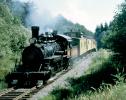 Date: 11/12/12 01:28 Re: Highest and Steepest Corrections Author: funnelfan I believe the longest continuous grade goes to the 44 miles of ruling 1.8% grade of the former SP between Oakridge and Cascade Summit in Oregon.
Ted Curphey Ontario, OR Date: 11/12/12 09:32 Re: to Cascade Summit Author: timz2 "Longest continuous grade" will be impossible to pin
down. It's unlikely 1.8% compensated was actually continuous for 44 miles-- the terrain wouldn't be that cooperative. And as always you can't pin down "steepest grade" until you specify a minimum length. But truth be told, once you do specify a minimum length, none of us has enough info to give a reliable answer. What was the steepest quarter-mile/half-mile/mile on any given RR? Compensated or not? Date: 11/12/12 10:15 Re: to Cascade Summit Author: jc76 There is often a big difference between ruling grade and steepest section of grade.
For example the Moffat Denver-East Portal has a ruling grade of 2%, however there are shorter steeper sections near Leyden and Clay. The same can be said of both slopes of Tehachapi just to name a couple... Perhaps a ruling grade map would have made for a better comparison. Although it would be tough to include branch lines this way as ruling grade was not always figured. Edited 4 time(s). Last edit at 11/12/12 10:30 by jc76. Date: 11/12/12 11:11 Re: to Cascade Summit Author: funnelfan timz2 Wrote:
------------------------------------------------------- It's unlikely 1.8% compensated was actually > continuous for 44 miles-- the terrain wouldn't be > that cooperative. > I didn't say that! I said it was 44 miles of continuous grade nominally ruled at 1.8%. Ted Curphey Ontario, OR Date: 11/12/12 14:54 Re: to Cascade Summit Author: timz2 Think no climb in the US has more than 44 miles
of constant "nominally ruled" grade? It'll depend on what "nominally ruled" means-- what does it mean? Date: 11/12/12 16:51 Re: to Cascade Summit Author: rehunn It means that the worst grade in the 44 miles is 1.8%. As to the SP, the Cloudcroft
had a couple spurs in the 5% range though not on the "main" line of the branch. |